Hellange geodata
Hellange (Esch-sur-Alzette) is a populated place; located in Luxembourg in Europe/Luxembourg (GMT+2) time zone. With population of 629 people, there are 128 cities with bigger population in this country. Compared to other cities in Luxembourg, 94.4% of cities are located further ↑North; 61.6% of cities are located further ←West and 65.5% of cities have higher elevation than Hellange. Note1


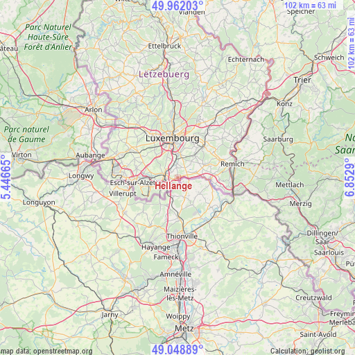
Hellange GPS coordinates[2]
49° 30' 27.324" North, 6° 8' 59.208" East
| Map corner | latitude | longitude |
|---|---|---|
| Upper-left | 49.96203°, | 5.44665° |
| Center: | 49.50759°, | 6.14978° |
| Lower-right: | 49.04889°, | 6.8529° |
| Map W x H: | 101.5×101.5 km | = 63.1×63.1mi |
| max Lat: | 50.13722° ⇑94.4% North |
| Hellange: | 49.50759° |
| min Lat: | ⇓5.6% South 49.45964° |
| min Long | Hellange | max Long |
| 5.76583° | 6.14978° | 6.50532° |
| W 61.6%⇐ | ⇒38.4% E |
Elevation
Elevation of Hellange is 260 m = 853 ft, and this is 22 m = 72 ft below average elevation for this country.
| Max E: |
502 m = 1647 ft | 65.5% |
| Avg. | 282 m = 925 ft | |
| Hellange | 260 m = 853 ft | |
Min E: |
143 m = 469 ft | 34.5% |
See also: Luxembourg elevation on elevation.city.
Geographical zone
Hellange is located in North temperate zone (between Tropic of Cancer and the Arctic Circle). Distance of this North polar circle is 1896.4 km =1178.4 mi to North.| Distance of | km | miles | from Hellange |
|---|---|---|---|
| North Pole | 4502.3 | 2797.6 | to North |
| Arctic Circle | 1896.4 | 1178.4 | to North |
| Tropic Cancer | 2898.8 | 1801.2 | to South |
| Equator | 5504.7 | 3420.5 | to South |


Nearby cities:
15 places around Hellange: (largest is in red/bold)
• Alzingen
6.5 km =4 mi,  8°
8°
• Aspelt
5.7 km =3.5 mi,  72°
72°
• Berchem
3.9 km =2.4 mi,  337°
337°
• Bettembourg
3.6 km =2.2 mi,  289°
289°
• Bivange
4.2 km =2.6 mi,  348°
348°
• Crauthem
3.1 km =1.9 mi,  356°
356°
• Dudelange
5.4 km =3.4 mi,  236°
236°
• Fentange
6.1 km =3.8 mi,  2°
2°
• Frisange
3 km =1.9 mi, 71°
• Hesperange
6.7 km =4.2 mi, 0°
• Huncherange
6.2 km =3.9 mi,  279°
279°
• Noertzange
6.8 km =4.2 mi,  271°
271°
• Peppange
2.4 km =1.5 mi,  322°
322°
• Roeser
3.3 km =2.1 mi, 355°
• Weiler-la-Tour
5.2 km =3.2 mi,  44°
44°
Sources, notices
• [Note1] Compared only with cities in Luxembourg existing in our database
• [Src1] Map data: © OpenStreetMap contributors (CC-BY-SA)
• [Src2] Other city data from geonames.org with taken over terms of usage.
• [Src3] Geographical zone / Annual Mean Temperature by Robert A. Rohde @ Wikipedia
