Alzingen geodata
Alzingen (Luxembourg) is a populated place; located in Luxembourg in Europe/Luxembourg (GMT+2) time zone. With population of 1,376 people, there are 60 cities with bigger population in this country. Compared to other cities in Luxembourg, 75.1% of cities are located further ↑North; 63.8% of cities are located further ←West and 61% of cities have higher elevation than Alzingen. Note1


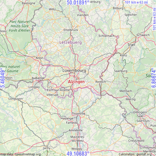
Alzingen GPS coordinates[2]
49° 33' 54" North, 6° 9' 48.996" East
| Map corner | latitude | longitude |
|---|---|---|
| Upper-left | 50.01891°, | 5.46049° |
| Center: | 49.565°, | 6.16361° |
| Lower-right: | 49.10683°, | 6.86674° |
| Map W x H: | 101.4×101.4 km | = 63×63mi |
| max Lat: | 50.13722° ⇑75.1% North |
| Alzingen: | 49.565° |
| min Lat: | ⇓24.9% South 49.45964° |
| min Long | Alzingen | max Long |
| 5.76583° | 6.16361° | 6.50532° |
| W 63.8%⇐ | ⇒36.2% E |
Elevation
Elevation of Alzingen is 265 m = 869 ft, and this is 17 m = 56 ft below average elevation for this country.
| Max E: |
502 m = 1647 ft | 61% |
| Avg. | 282 m = 925 ft | |
| Alzingen | 265 m = 869 ft | |
Min E: |
143 m = 469 ft | 39% |
See also: Luxembourg elevation on elevation.city.
Geographical zone
Alzingen is located in North temperate zone (between Tropic of Cancer and the Arctic Circle). Distance of this North polar circle is 1890.1 km =1174.5 mi to North.| Distance of | km | miles | from Alzingen |
|---|---|---|---|
| North Pole | 4496 | 2793.7 | to North |
| Arctic Circle | 1890.1 | 1174.5 | to North |
| Tropic Cancer | 2905.2 | 1805.2 | to South |
| Equator | 5511.1 | 3424.4 | to South |


Nearby cities:
15 places around Alzingen: (largest is in red/bold)
• Aspelt
6.4 km =4 mi,  136°
136°
• Berchem
3.7 km =2.3 mi,  222°
222°
• Bivange
2.9 km =1.8 mi, 219°
• Contern
4.9 km =3 mi,  67°
67°
• Crauthem
3.5 km =2.2 mi,  200°
200°
• Fentange
0.7 km =0.4 mi,  250°
250°
• Frisange
5.7 km =3.5 mi,  161°
161°
• Hellange
6.5 km =4 mi,  188°
188°
• Hesperange
0.9 km =0.6 mi,  291°
291°
• Itzig
2.6 km =1.6 mi,  11°
11°
• Kirchberg
6.6 km =4.1 mi,  351°
351°
• Luxembourg
5.7 km =3.5 mi,  334°
334°
• Peppange
5.1 km =3.2 mi,  208°
208°
• Roeser
3.3 km =2.1 mi, 202°
• Weiler-la-Tour
3.8 km =2.4 mi, 135°
Sources, notices
• [Note1] Compared only with cities in Luxembourg existing in our database
• [Src1] Map data: © OpenStreetMap contributors (CC-BY-SA)
• [Src2] Other city data from geonames.org with taken over terms of usage.
• [Src3] Geographical zone / Annual Mean Temperature by Robert A. Rohde @ Wikipedia
