Roeser geodata
Roeser (Esch-sur-Alzette) is a seat of a third-order administrative division; located in Luxembourg in Europe/Luxembourg (GMT+2) time zone. With population of 708 people, there are 110 cities with bigger population in this country. Compared to other cities in Luxembourg, 83.6% of cities are located further ↑North; 59.9% of cities are located further ←West and 55.4% of cities have higher elevation than Roeser. Note1


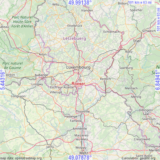
Roeser GPS coordinates[2]
49° 32' 13.956" North, 6° 8' 46.644" East
| Map corner | latitude | longitude |
|---|---|---|
| Upper-left | 49.99138°, | 5.44316° |
| Center: | 49.53721°, | 6.14629° |
| Lower-right: | 49.07878°, | 6.84941° |
| Map W x H: | 101.5×101.5 km | = 63.1×63.1mi |
| max Lat: | 50.13722° ⇑83.6% North |
| Roeser: | 49.53721° |
| min Lat: | ⇓16.4% South 49.45964° |
| min Long | Roeser | max Long |
| 5.76583° | 6.14629° | 6.50532° |
| W 59.9%⇐ | ⇒40.1% E |
Elevation
Elevation of Roeser is 276 m = 906 ft, and this is 6 m = 20 ft below average elevation for this country.
| Max E: |
502 m = 1647 ft | 55.4% |
| Avg. | 282 m = 925 ft | |
| Roeser | 276 m = 906 ft | |
Min E: |
143 m = 469 ft | 44.6% |
See also: Luxembourg elevation on elevation.city.
Geographical zone
Roeser is located in North temperate zone (between Tropic of Cancer and the Arctic Circle). Distance of this North polar circle is 1893.2 km =1176.4 mi to North.| Distance of | km | miles | from Roeser |
|---|---|---|---|
| North Pole | 4499 | 2795.5 | to North |
| Arctic Circle | 1893.2 | 1176.4 | to North |
| Tropic Cancer | 2902.1 | 1803.3 | to South |
| Equator | 5508 | 3422.5 | to South |


Nearby cities:
15 places around Roeser: (largest is in red/bold)
• Alzingen
3.3 km =2.1 mi,  22°
22°
• Aspelt
5.9 km =3.7 mi,  105°
105°
• Berchem
1.3 km =0.8 mi,  285°
285°
• Bettembourg
3.8 km =2.4 mi,  236°
236°
• Bivange
1 km =0.6 mi,  322°
322°
• Crauthem
0.2 km =0.1 mi,  165°
165°
• Fentange
2.9 km =1.8 mi,  10°
10°
• Frisange
3.8 km =2.4 mi,  127°
127°
• Hellange
3.3 km =2.1 mi,  175°
175°
• Hesperange
3.4 km =2.1 mi, 6°
• Huncherange
6.3 km =3.9 mi,  248°
248°
• Itzig
5.9 km =3.7 mi, 17°
• Leudelange
6.8 km =4.2 mi,  300°
300°
• Peppange
1.9 km =1.2 mi,  220°
220°
• Weiler-la-Tour
4 km =2.5 mi,  84°
84°
Sources, notices
• [Note1] Compared only with cities in Luxembourg existing in our database
• [Src1] Map data: © OpenStreetMap contributors (CC-BY-SA)
• [Src2] Other city data from geonames.org with taken over terms of usage.
• [Src3] Geographical zone / Annual Mean Temperature by Robert A. Rohde @ Wikipedia
