Hesperange geodata
Hesperange (Luxembourg) is a seat of a third-order administrative division; located in Luxembourg in Europe/Luxembourg (GMT+2) time zone. With population of 1,937 people, there are 38 cities with bigger population in this country. Compared to other cities in Luxembourg, 73.4% of cities are located further ↑North; 62.1% of cities are located further ←West and 58.2% of cities have higher elevation than Hesperange. Note1


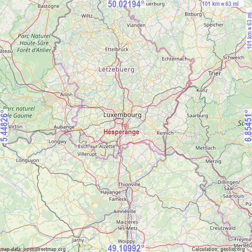
Hesperange GPS coordinates[2]
49° 34' 5.016" North, 6° 9' 5.004" East
| Map corner | latitude | longitude |
|---|---|---|
| Upper-left | 50.02194°, | 5.44826° |
| Center: | 49.56806°, | 6.15139° |
| Lower-right: | 49.10992°, | 6.85451° |
| Map W x H: | 101.4×101.4 km | = 63×63mi |
| max Lat: | 50.13722° ⇑73.4% North |
| Hesperange: | 49.56806° |
| min Lat: | ⇓26.6% South 49.45964° |
| min Long | Hesperange | max Long |
| 5.76583° | 6.15139° | 6.50532° |
| W 62.1%⇐ | ⇒37.9% E |
Elevation
Elevation of Hesperange is 270 m = 886 ft, and this is 12 m = 39 ft below average elevation for this country.
| Max E: |
502 m = 1647 ft | 58.2% |
| Avg. | 282 m = 925 ft | |
| Hesperange | 270 m = 886 ft | |
Min E: |
143 m = 469 ft | 41.8% |
See also: Luxembourg elevation on elevation.city.
Geographical zone
Hesperange is located in North temperate zone (between Tropic of Cancer and the Arctic Circle). Distance of this North polar circle is 1889.7 km =1174.2 mi to North.| Distance of | km | miles | from Hesperange |
|---|---|---|---|
| North Pole | 4495.6 | 2793.4 | to North |
| Arctic Circle | 1889.7 | 1174.2 | to North |
| Tropic Cancer | 2905.5 | 1805.4 | to South |
| Equator | 5511.5 | 3424.7 | to South |


Nearby cities:
15 places around Hesperange: (largest is in red/bold)
• Alzingen
0.9 km =0.6 mi,  111°
111°
• Berchem
3.5 km =2.2 mi,  207°
207°
• Bettembourg
6.5 km =4 mi, 212°
• Bivange
2.8 km =1.7 mi,  200°
200°
• Contern
5.6 km =3.5 mi,  74°
74°
• Crauthem
3.6 km =2.2 mi,  185°
185°
• Fentange
0.6 km =0.4 mi,  162°
162°
• Frisange
6.4 km =4 mi, 155°
• Itzig
2.6 km =1.6 mi,  32°
32°
• Kirchberg
6.2 km =3.9 mi,  358°
358°
• Leudelange
6.2 km =3.9 mi,  270°
270°
• Luxembourg
5.1 km =3.2 mi,  342°
342°
• Peppange
5.1 km =3.2 mi, 197°
• Roeser
3.4 km =2.1 mi, 186°
• Weiler-la-Tour
4.7 km =2.9 mi,  130°
130°
Sources, notices
• [Note1] Compared only with cities in Luxembourg existing in our database
• [Src1] Map data: © OpenStreetMap contributors (CC-BY-SA)
• [Src2] Other city data from geonames.org with taken over terms of usage.
• [Src3] Geographical zone / Annual Mean Temperature by Robert A. Rohde @ Wikipedia
