Nospelt geodata
Nospelt (Capellen) is a populated place; located in Luxembourg in Europe/Luxembourg (GMT+2) time zone. With population of 766 people, there are 104 cities with bigger population in this country. Compared to other cities in Luxembourg, 53.1% of cities are located further ↓South; 70.6% of cities are located further →East and 80.2% of cities have lower elevation than Nospelt. Note1


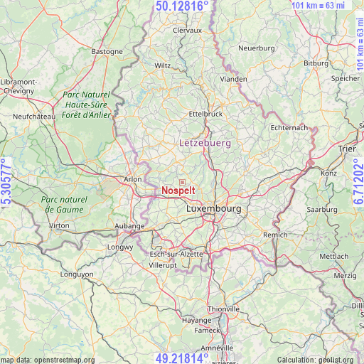
Nospelt GPS coordinates[2]
49° 40' 31.008" North, 6° 0' 32.004" East
| Map corner | latitude | longitude |
|---|---|---|
| Upper-left | 50.12816°, | 5.30577° |
| Center: | 49.67528°, | 6.00889° |
| Lower-right: | 49.21814°, | 6.71202° |
| Map W x H: | 101.2×101.2 km | = 62.9×62.9mi |
| max Lat: | 50.13722° ⇑46.9% North |
| Nospelt: | 49.67528° |
| min Lat: | ⇓53.1% South 49.45964° |
| min Long | Nospelt | max Long |
| 5.76583° | 6.00889° | 6.50532° |
| W 29.4%⇐ | ⇒70.6% E |
Elevation
Elevation of Nospelt is 328 m = 1076 ft, and this is 46 m = 151 ft above average elevation for this country.
| Max E: |
502 m = 1647 ft | 19.8% |
| Nospelt | 328 m 1076 ft | |
| Avg. | 282 m = 925 ft | |
Min E: |
143 m = 469 ft | 80.2% |
See also: Luxembourg elevation on elevation.city.
Geographical zone
Nospelt is located in North temperate zone (between Tropic of Cancer and the Arctic Circle). Distance of this North polar circle is 1877.8 km =1166.8 mi to North.| Distance of | km | miles | from Nospelt |
|---|---|---|---|
| North Pole | 4483.7 | 2786 | to North |
| Arctic Circle | 1877.8 | 1166.8 | to North |
| Tropic Cancer | 2917.5 | 1812.8 | to South |
| Equator | 5523.4 | 3432.1 | to South |


Nearby cities:
15 places around Nospelt: (largest is in red/bold)
• Bridel
5.6 km =3.5 mi,  112°
112°
• Brouch
6.8 km =4.2 mi,  8°
8°
• Capellen
3.6 km =2.2 mi,  201°
201°
• Hagen
6.3 km =3.9 mi,  242°
242°
• Holzem
6.7 km =4.2 mi,  191°
191°
• Kehlen
2.1 km =1.3 mi, 111°
• Keispelt
4.7 km =2.9 mi,  63°
63°
• Koerich
4.3 km =2.7 mi,  262°
262°
• Kopstal
4.8 km =3 mi,  104°
104°
• Mamer
5.4 km =3.4 mi,  168°
168°
• Olm
2.1 km =1.3 mi, 197°
• Saeul
6 km =3.7 mi,  344°
344°
• Septfontaines
4.2 km =2.6 mi,  313°
313°
• Steinfort
6.6 km =4.1 mi, 256°
• Tuntange
4.7 km =2.9 mi,  1°
1°
Sources, notices
• [Note1] Compared only with cities in Luxembourg existing in our database
• [Src1] Map data: © OpenStreetMap contributors (CC-BY-SA)
• [Src2] Other city data from geonames.org with taken over terms of usage.
• [Src3] Geographical zone / Annual Mean Temperature by Robert A. Rohde @ Wikipedia
