Brouch geodata
Brouch (Mersch) is a populated place; located in Luxembourg in Europe/Luxembourg (GMT+2) time zone. With population of 676 people, there are 117 cities with bigger population in this country. Compared to other cities in Luxembourg, 67.2% of cities are located further ↓South; 67.8% of cities are located further →East and 68.9% of cities have lower elevation than Brouch. Note1


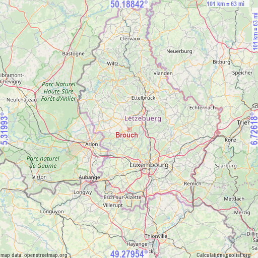
Brouch GPS coordinates[2]
49° 44' 9.996" North, 6° 1' 23.016" East
| Map corner | latitude | longitude |
|---|---|---|
| Upper-left | 50.18842°, | 5.31993° |
| Center: | 49.73611°, | 6.02306° |
| Lower-right: | 49.27954°, | 6.72618° |
| Map W x H: | 101.1×101.1 km | = 62.8×62.8mi |
| max Lat: | 50.13722° ⇑32.8% North |
| Brouch: | 49.73611° |
| min Lat: | ⇓67.2% South 49.45964° |
| min Long | Brouch | max Long |
| 5.76583° | 6.02306° | 6.50532° |
| W 32.2%⇐ | ⇒67.8% E |
Elevation
Elevation of Brouch is 307 m = 1007 ft, and this is 25 m = 82 ft above average elevation for this country.
| Max E: |
502 m = 1647 ft | 31.1% |
| Brouch | 307 m 1007 ft | |
| Avg. | 282 m = 925 ft | |
Min E: |
143 m = 469 ft | 68.9% |
See also: Luxembourg elevation on elevation.city.
Geographical zone
Brouch is located in North temperate zone (between Tropic of Cancer and the Arctic Circle). Distance of this North polar circle is 1871 km =1162.6 mi to North.| Distance of | km | miles | from Brouch |
|---|---|---|---|
| North Pole | 4476.9 | 2781.8 | to North |
| Arctic Circle | 1871 | 1162.6 | to North |
| Tropic Cancer | 2924.2 | 1817 | to South |
| Equator | 5530.1 | 3436.2 | to South |


Nearby cities:
15 places around Brouch: (largest is in red/bold)
• Beringen
7.2 km =4.5 mi,  69°
69°
• Bissen
6.5 km =4 mi,  28°
28°
• Boevange-sur-Attert
4.1 km =2.5 mi,  352°
352°
• Kehlen
7.6 km =4.7 mi,  173°
173°
• Keispelt
5.7 km =3.5 mi,  145°
145°
• Lintgen
7.8 km =4.8 mi,  101°
101°
• Mersch
6.1 km =3.8 mi,  76°
76°
• Nospelt
6.8 km =4.2 mi,  188°
188°
• Reckange
4.6 km =2.9 mi, 70°
• Rollingen
6.6 km =4.1 mi, 84°
• Saeul
2.8 km =1.7 mi,  249°
249°
• Septfontaines
5.6 km =3.5 mi,  225°
225°
• Tuntange
2.2 km =1.4 mi,  204°
204°
• Useldange
4.8 km =3 mi,  321°
321°
• Vichten
7.6 km =4.7 mi, 347°
Sources, notices
• [Note1] Compared only with cities in Luxembourg existing in our database
• [Src1] Map data: © OpenStreetMap contributors (CC-BY-SA)
• [Src2] Other city data from geonames.org with taken over terms of usage.
• [Src3] Geographical zone / Annual Mean Temperature by Robert A. Rohde @ Wikipedia
