Capellen geodata
Capellen is a seat of a second-order administrative division; located in Luxembourg in Europe/Luxembourg (GMT+2) time zone. With population of 1,330 people, there are 63 cities with bigger population in this country. Compared to other cities in Luxembourg, 57.6% of cities are located further ↑North; 74% of cities are located further →East and 74.6% of cities have lower elevation than Capellen. Note1


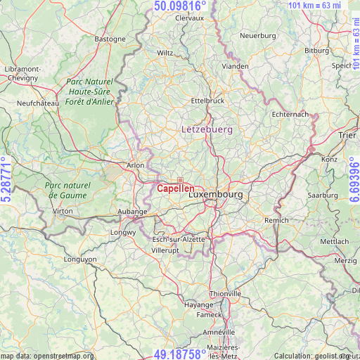
Capellen GPS coordinates[2]
49° 38' 42" North, 5° 59' 26.988" East
| Map corner | latitude | longitude |
|---|---|---|
| Upper-left | 50.09816°, | 5.28771° |
| Center: | 49.645°, | 5.99083° |
| Lower-right: | 49.18758°, | 6.69396° |
| Map W x H: | 101.2×101.2 km | = 62.9×62.9mi |
| max Lat: | 50.13722° ⇑57.6% North |
| Capellen: | 49.645° |
| min Lat: | ⇓42.4% South 49.45964° |
| min Long | Capellen | max Long |
| 5.76583° | 5.99083° | 6.50532° |
| W 26%⇐ | ⇒74% E |
Elevation
Elevation of Capellen is 316 m = 1037 ft, and this is 34 m = 112 ft above average elevation for this country.
| Max E: |
502 m = 1647 ft | 25.4% |
| Capellen | 316 m 1037 ft | |
| Avg. | 282 m = 925 ft | |
Min E: |
143 m = 469 ft | 74.6% |
See also: Luxembourg elevation on elevation.city.
Geographical zone
Capellen is located in North temperate zone (between Tropic of Cancer and the Arctic Circle). Distance of this North polar circle is 1881.2 km =1168.9 mi to North.| Distance of | km | miles | from Capellen |
|---|---|---|---|
| North Pole | 4487.1 | 2788.2 | to North |
| Arctic Circle | 1881.2 | 1168.9 | to North |
| Tropic Cancer | 2914.1 | 1810.7 | to South |
| Equator | 5520 | 3430 | to South |


Nearby cities:
15 places around Capellen: (largest is in red/bold)
• Bertrange
5.7 km =3.5 mi,  131°
131°
• Bridel
6.5 km =4 mi,  79°
79°
• Dippach
6.5 km =4 mi,  184°
184°
• Garnich
4.2 km =2.6 mi,  221°
221°
• Hagen
4.3 km =2.7 mi,  276°
276°
• Holzem
3.2 km =2 mi, 180°
• Kehlen
4.1 km =2.5 mi,  51°
51°
• Kleinbettingen
5.4 km =3.4 mi,  271°
271°
• Koerich
4 km =2.5 mi,  313°
313°
• Kopstal
6.3 km =3.9 mi,  69°
69°
• Mamer
3 km =1.9 mi, 129°
• Nospelt
3.6 km =2.2 mi,  21°
21°
• Olm
1.5 km =0.9 mi,  26°
26°
• Steinfort
5.5 km =3.4 mi,  289°
289°
• Strassen
6.5 km =4 mi,  114°
114°
Sources, notices
• [Note1] Compared only with cities in Luxembourg existing in our database
• [Src1] Map data: © OpenStreetMap contributors (CC-BY-SA)
• [Src2] Other city data from geonames.org with taken over terms of usage.
• [Src3] Geographical zone / Annual Mean Temperature by Robert A. Rohde @ Wikipedia
