Contern geodata
Contern (Luxembourg) is a seat of a third-order administrative division; located in Luxembourg in Europe/Luxembourg (GMT+2) time zone. With population of 1,083 people, there are 74 cities with bigger population in this country. Compared to other cities in Luxembourg, 71.2% of cities are located further ↑North; 72.3% of cities are located further ←West and 83.1% of cities have lower elevation than Contern. Note1


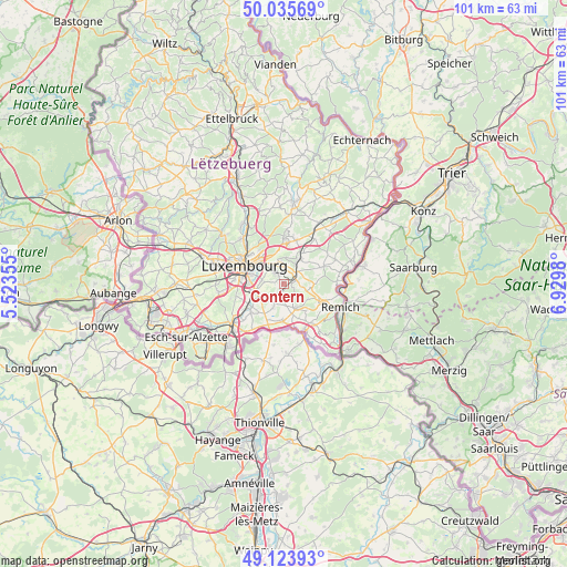
Contern GPS coordinates[2]
49° 34' 54.984" North, 6° 13' 36.012" East
| Map corner | latitude | longitude |
|---|---|---|
| Upper-left | 50.03569°, | 5.52355° |
| Center: | 49.58194°, | 6.22667° |
| Lower-right: | 49.12393°, | 6.9298° |
| Map W x H: | 101.4×101.4 km | = 63×63mi |
| max Lat: | 50.13722° ⇑71.2% North |
| Contern: | 49.58194° |
| min Lat: | ⇓28.8% South 49.45964° |
| min Long | Contern | max Long |
| 5.76583° | 6.22667° | 6.50532° |
| W 72.3%⇐ | ⇒27.7% E |
Elevation
Elevation of Contern is 333 m = 1093 ft, and this is 51 m = 167 ft above average elevation for this country.
| Max E: |
502 m = 1647 ft | 16.9% |
| Contern | 333 m 1093 ft | |
| Avg. | 282 m = 925 ft | |
Min E: |
143 m = 469 ft | 83.1% |
See also: Luxembourg elevation on elevation.city.
Geographical zone
Contern is located in North temperate zone (between Tropic of Cancer and the Arctic Circle). Distance of this North polar circle is 1888.2 km =1173.3 mi to North.| Distance of | km | miles | from Contern |
|---|---|---|---|
| North Pole | 4494.1 | 2792.5 | to North |
| Arctic Circle | 1888.2 | 1173.3 | to North |
| Tropic Cancer | 2907.1 | 1806.4 | to South |
| Equator | 5513 | 3425.6 | to South |


Nearby cities:
15 places around Contern: (largest is in red/bold)
• Alzingen
4.9 km =3 mi,  247°
247°
• Aspelt
6.6 km =4.1 mi,  181°
181°
• Dalheim
5.2 km =3.2 mi,  152°
152°
• Fentange
5.7 km =3.5 mi, 247°
• Hesperange
5.6 km =3.5 mi, 254°
• Itzig
4.1 km =2.5 mi,  278°
278°
• Moutfort
2.1 km =1.3 mi,  79°
79°
• Münsbach
6.3 km =3.9 mi,  25°
25°
• Oetrange
2.9 km =1.8 mi,  56°
56°
• Sandweiler
3.7 km =2.3 mi,  354°
354°
• Schrassig
3.9 km =2.4 mi,  36°
36°
• Schuttrange
5.3 km =3.3 mi, 35°
• Uebersyren
6.6 km =4.1 mi, 33°
• Waldbredimus
5.2 km =3.2 mi,  122°
122°
• Weiler-la-Tour
4.9 km =3 mi,  202°
202°
Sources, notices
• [Note1] Compared only with cities in Luxembourg existing in our database
• [Src1] Map data: © OpenStreetMap contributors (CC-BY-SA)
• [Src2] Other city data from geonames.org with taken over terms of usage.
• [Src3] Geographical zone / Annual Mean Temperature by Robert A. Rohde @ Wikipedia
