Rollingen geodata
Rollingen (Mersch) is a populated place; located in Luxembourg in Europe/Luxembourg (GMT+2) time zone. With population of 1,448 people, there are 56 cities with bigger population in this country. Compared to other cities in Luxembourg, 67.8% of cities are located further ↓South; 50.8% of cities are located further →East and 80.8% of cities have higher elevation than Rollingen. Note1


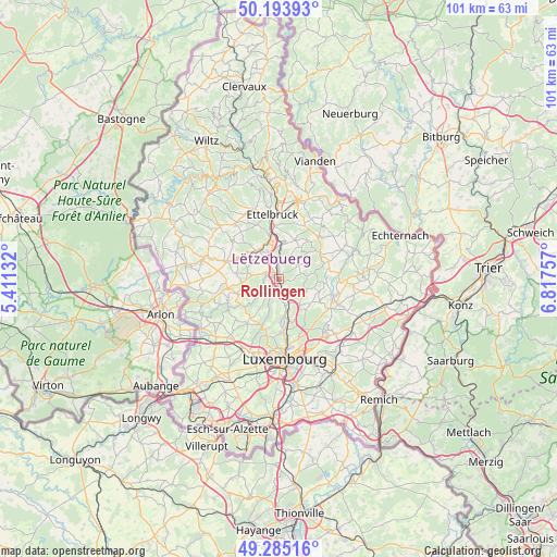
Rollingen GPS coordinates[2]
49° 44' 30.012" North, 6° 6' 51.984" East
| Map corner | latitude | longitude |
|---|---|---|
| Upper-left | 50.19393°, | 5.41132° |
| Center: | 49.74167°, | 6.11444° |
| Lower-right: | 49.28516°, | 6.81757° |
| Map W x H: | 101×101 km | = 62.8×62.8mi |
| max Lat: | 50.13722° ⇑32.2% North |
| Rollingen: | 49.74167° |
| min Lat: | ⇓67.8% South 49.45964° |
| min Long | Rollingen | max Long |
| 5.76583° | 6.11444° | 6.50532° |
| W 49.2%⇐ | ⇒50.8% E |
Elevation
Elevation of Rollingen is 227 m = 745 ft, and this is 55 m = 180 ft below average elevation for this country.
| Max E: |
502 m = 1647 ft | 80.8% |
| Avg. | 282 m = 925 ft | |
| Rollingen | 227 m = 745 ft | |
Min E: |
143 m = 469 ft | 19.2% |
See also: Luxembourg elevation on elevation.city.
Geographical zone
Rollingen is located in North temperate zone (between Tropic of Cancer and the Arctic Circle). Distance of this North polar circle is 1870.4 km =1162.2 mi to North.| Distance of | km | miles | from Rollingen |
|---|---|---|---|
| North Pole | 4476.3 | 2781.4 | to North |
| Arctic Circle | 1870.4 | 1162.2 | to North |
| Tropic Cancer | 2924.8 | 1817.4 | to South |
| Equator | 5530.8 | 3436.7 | to South |


Nearby cities:
15 places around Rollingen: (largest is in red/bold)
• Beringen
1.9 km =1.2 mi,  5°
5°
• Bissen
6.2 km =3.9 mi,  325°
325°
• Bofferdange
6 km =3.7 mi,  162°
162°
• Brouch
6.6 km =4.1 mi,  264°
264°
• Colmar
7.7 km =4.8 mi,  350°
350°
• Fischbach
5.2 km =3.2 mi,  84°
84°
• Helmdange
5.7 km =3.5 mi, 159°
• Keispelt
6.3 km =3.9 mi,  212°
212°
• Lintgen
2.4 km =1.5 mi,  152°
152°
• Lorentzweiler
4.9 km =3 mi, 155°
• Mersch
1 km =0.6 mi,  323°
323°
• Müllendorf
6.9 km =4.3 mi,  170°
170°
• Nommern
6.6 km =4.1 mi,  40°
40°
• Reckange
2.4 km =1.5 mi,  291°
291°
• Steinsel
7.2 km =4.5 mi, 174°
Sources, notices
• [Note1] Compared only with cities in Luxembourg existing in our database
• [Src1] Map data: © OpenStreetMap contributors (CC-BY-SA)
• [Src2] Other city data from geonames.org with taken over terms of usage.
• [Src3] Geographical zone / Annual Mean Temperature by Robert A. Rohde @ Wikipedia
