Bertrange geodata
Bertrange (Luxembourg) is a seat of a third-order administrative division; located in Luxembourg in Europe/Luxembourg (GMT+2) time zone. With population of 5,615 people, there are 9 cities with bigger population in this country. Compared to other cities in Luxembourg, 64.4% of cities are located further ↑North; 62.1% of cities are located further →East and 53.1% of cities have lower elevation than Bertrange. Note1


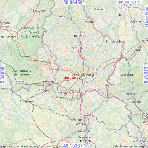
Bertrange GPS coordinates[2]
49° 36' 39.996" North, 6° 3' 0" East
| Map corner | latitude | longitude |
|---|---|---|
| Upper-left | 50.06459°, | 5.34688° |
| Center: | 49.61111°, | 6.05° |
| Lower-right: | 49.15337°, | 6.75313° |
| Map W x H: | 101.3×101.3 km | = 62.9×62.9mi |
| max Lat: | 50.13722° ⇑64.4% North |
| Bertrange: | 49.61111° |
| min Lat: | ⇓35.6% South 49.45964° |
| min Long | Bertrange | max Long |
| 5.76583° | 6.05° | 6.50532° |
| W 37.9%⇐ | ⇒62.1% E |
Elevation
Elevation of Bertrange is 287 m = 942 ft, and this is 5 m = 16 ft above average elevation for this country.
| Max E: |
502 m = 1647 ft | 46.9% |
| Bertrange | 287 m 942 ft | |
| Avg. | 282 m = 925 ft | |
Min E: |
143 m = 469 ft | 53.1% |
See also: Luxembourg elevation on elevation.city.
Geographical zone
Bertrange is located in North temperate zone (between Tropic of Cancer and the Arctic Circle). Distance of this North polar circle is 1884.9 km =1171.2 mi to North.| Distance of | km | miles | from Bertrange |
|---|---|---|---|
| North Pole | 4490.8 | 2790.5 | to North |
| Arctic Circle | 1884.9 | 1171.2 | to North |
| Tropic Cancer | 2910.3 | 1808.4 | to South |
| Equator | 5516.2 | 3427.6 | to South |


Nearby cities:
15 places around Bertrange: (largest is in red/bold)
• Bettange-sur-Mess
6.2 km =3.9 mi,  230°
230°
• Bridel
5.4 km =3.4 mi,  23°
23°
• Béreldange
7 km =4.3 mi,  45°
45°
• Capellen
5.7 km =3.5 mi,  311°
311°
• Dippach
5.5 km =3.4 mi,  240°
240°
• Garnich
7.1 km =4.4 mi,  275°
275°
• Holzem
4.3 km =2.7 mi, 277°
• Kehlen
6.4 km =4 mi,  350°
350°
• Kopstal
6.2 km =3.9 mi, 15°
• Leudelange
4.9 km =3 mi,  166°
166°
• Luxembourg
5.8 km =3.6 mi,  89°
89°
• Mamer
2.6 km =1.6 mi, 313°
• Olm
6.3 km =3.9 mi,  325°
325°
• Reckange-sur-Mess
6.2 km =3.9 mi,  208°
208°
• Strassen
2 km =1.2 mi,  57°
57°
Sources, notices
• [Note1] Compared only with cities in Luxembourg existing in our database
• [Src1] Map data: © OpenStreetMap contributors (CC-BY-SA)
• [Src2] Other city data from geonames.org with taken over terms of usage.
• [Src3] Geographical zone / Annual Mean Temperature by Robert A. Rohde @ Wikipedia
