Eischen geodata
Eischen (Capellen) is a populated place; located in Luxembourg in Europe/Luxembourg (GMT+2) time zone. With population of 1,559 people, there are 48 cities with bigger population in this country. Compared to other cities in Luxembourg, 55.9% of cities are located further ↓South; 95.5% of cities are located further →East and 61% of cities have lower elevation than Eischen. Note1


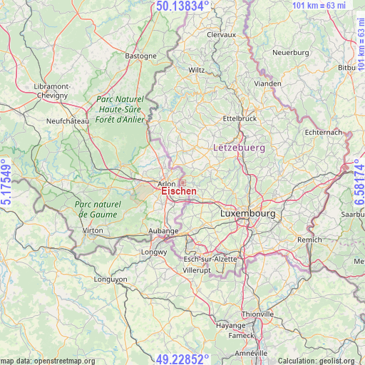
Eischen GPS coordinates[2]
49° 41' 8.016" North, 5° 52' 42.996" East
| Map corner | latitude | longitude |
|---|---|---|
| Upper-left | 50.13834°, | 5.17549° |
| Center: | 49.68556°, | 5.87861° |
| Lower-right: | 49.22852°, | 6.58174° |
| Map W x H: | 101.2×101.2 km | = 62.9×62.9mi |
| max Lat: | 50.13722° ⇑44.1% North |
| Eischen: | 49.68556° |
| min Lat: | ⇓55.9% South 49.45964° |
| min Long | Eischen | max Long |
| 5.76583° | 5.87861° | 6.50532° |
| W 4.5%⇐ | ⇒95.5% E |
Elevation
Elevation of Eischen is 298 m = 978 ft, and this is 16 m = 52 ft above average elevation for this country.
| Max E: |
502 m = 1647 ft | 39% |
| Eischen | 298 m 978 ft | |
| Avg. | 282 m = 925 ft | |
Min E: |
143 m = 469 ft | 61% |
See also: Luxembourg elevation on elevation.city.
Geographical zone
Eischen is located in North temperate zone (between Tropic of Cancer and the Arctic Circle). Distance of this North polar circle is 1876.7 km =1166.1 mi to North.| Distance of | km | miles | from Eischen |
|---|---|---|---|
| North Pole | 4482.5 | 2785.3 | to North |
| Arctic Circle | 1876.7 | 1166.1 | to North |
| Tropic Cancer | 2918.6 | 1813.5 | to South |
| Equator | 5524.5 | 3432.8 | to South |


Nearby cities:
15 places around Eischen: (largest is in red/bold)
• Beckerich
5.1 km =3.2 mi,  3°
3°
• Capellen
9.3 km =5.8 mi,  119°
119°
• Clemency
9.9 km =6.2 mi,  181°
181°
• Ell
8.8 km =5.5 mi,  349°
349°
• Garnich
9.3 km =5.8 mi,  145°
145°
• Hagen
5.5 km =3.4 mi,  136°
136°
• Hobscheid
2.6 km =1.6 mi,  82°
82°
• Kleinbettingen
5.1 km =3.2 mi, 148°
• Koerich
5.4 km =3.4 mi,  108°
108°
• Nospelt
9.4 km =5.8 mi,  96°
96°
• Olm
9.3 km =5.8 mi, 109°
• Redange-sur-Attert
8.8 km =5.5 mi,  5°
5°
• Saeul
9 km =5.6 mi,  59°
59°
• Septfontaines
6.6 km =4.1 mi,  74°
74°
• Steinfort
4 km =2.5 mi,  132°
132°
Sources, notices
• [Note1] Compared only with cities in Luxembourg existing in our database
• [Src1] Map data: © OpenStreetMap contributors (CC-BY-SA)
• [Src2] Other city data from geonames.org with taken over terms of usage.
• [Src3] Geographical zone / Annual Mean Temperature by Robert A. Rohde @ Wikipedia
