Ell geodata
Ell (Redange) is a seat of a third-order administrative division; located in Luxembourg in Europe/Luxembourg (GMT+2) time zone. With population of 359 people, there are 158 cities with bigger population in this country. Compared to other cities in Luxembourg, 71.8% of cities are located further ↓South; 96.6% of cities are located further →East and 51.4% of cities have higher elevation than Ell. Note1


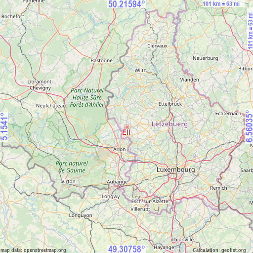
Ell GPS coordinates[2]
49° 45' 50.004" North, 5° 51' 25.992" East
| Map corner | latitude | longitude |
|---|---|---|
| Upper-left | 50.21594°, | 5.1541° |
| Center: | 49.76389°, | 5.85722° |
| Lower-right: | 49.30758°, | 6.56035° |
| Map W x H: | 101×101 km | = 62.8×62.8mi |
| max Lat: | 50.13722° ⇑28.2% North |
| Ell: | 49.76389° |
| min Lat: | ⇓71.8% South 49.45964° |
| min Long | Ell | max Long |
| 5.76583° | 5.85722° | 6.50532° |
| W 3.4%⇐ | ⇒96.6% E |
Elevation
Elevation of Ell is 281 m = 922 ft, and this is 1 m = 3 ft below average elevation for this country.
| Max E: |
502 m = 1647 ft | 51.4% |
| Avg. | 282 m = 925 ft | |
| Ell | 281 m = 922 ft | |
Min E: |
143 m = 469 ft | 48.6% |
See also: Luxembourg elevation on elevation.city.
Geographical zone
Ell is located in North temperate zone (between Tropic of Cancer and the Arctic Circle). Distance of this North polar circle is 1867.9 km =1160.7 mi to North.| Distance of | km | miles | from Ell |
|---|---|---|---|
| North Pole | 4473.8 | 2779.9 | to North |
| Arctic Circle | 1867.9 | 1160.7 | to North |
| Tropic Cancer | 2927.3 | 1818.9 | to South |
| Equator | 5533.2 | 3438.2 | to South |


Nearby cities:
15 places around Ell: (largest is in red/bold)
• Beckerich
4.1 km =2.5 mi,  153°
153°
• Bettborn
7 km =4.3 mi,  59°
59°
• Boevange-sur-Attert
11.4 km =7.1 mi,  85°
85°
• Eischen
8.8 km =5.5 mi,  169°
169°
• Grosbous
10.6 km =6.6 mi,  48°
48°
• Hobscheid
9.3 km =5.8 mi, 153°
• Perlé
8.4 km =5.2 mi,  309°
309°
• Platen
6.2 km =3.9 mi, 62°
• Rambrouch
7.5 km =4.7 mi,  353°
353°
• Redange-sur-Attert
2.4 km =1.5 mi, 88°
• Saeul
10.1 km =6.3 mi,  113°
113°
• Septfontaines
10.5 km =6.5 mi,  131°
131°
• Useldange
9 km =5.6 mi, 85°
• Vichten
11.1 km =6.9 mi,  66°
66°
• Wahl
8.8 km =5.5 mi,  23°
23°
Sources, notices
• [Note1] Compared only with cities in Luxembourg existing in our database
• [Src1] Map data: © OpenStreetMap contributors (CC-BY-SA)
• [Src2] Other city data from geonames.org with taken over terms of usage.
• [Src3] Geographical zone / Annual Mean Temperature by Robert A. Rohde @ Wikipedia
