Kayl geodata
Kayl (Esch-sur-Alzette) is a seat of a third-order administrative division; located in Luxembourg in Europe/Luxembourg (GMT+2) time zone. With population of 4,396 people, there are 19 cities with bigger population in this country. Compared to other cities in Luxembourg, 97.2% of cities are located further ↑North; 64.4% of cities are located further →East and 51.4% of cities have lower elevation than Kayl. Note1


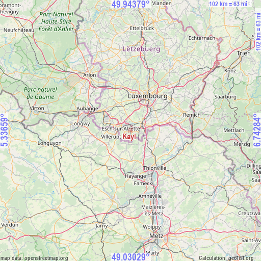
Kayl GPS coordinates[2]
49° 29' 21.012" North, 6° 2' 22.992" East
| Map corner | latitude | longitude |
|---|---|---|
| Upper-left | 49.94379°, | 5.33659° |
| Center: | 49.48917°, | 6.03972° |
| Lower-right: | 49.03029°, | 6.74284° |
| Map W x H: | 101.6×101.6 km | = 63.1×63.1mi |
| max Lat: | 50.13722° ⇑97.2% North |
| Kayl: | 49.48917° |
| min Lat: | ⇓2.8% South 49.45964° |
| min Long | Kayl | max Long |
| 5.76583° | 6.03972° | 6.50532° |
| W 35.6%⇐ | ⇒64.4% E |
Elevation
Elevation of Kayl is 284 m = 932 ft, and this is 2 m = 7 ft above average elevation for this country.
| Max E: |
502 m = 1647 ft | 48.6% |
| Kayl | 284 m 932 ft | |
| Avg. | 282 m = 925 ft | |
Min E: |
143 m = 469 ft | 51.4% |
See also: Luxembourg elevation on elevation.city.
Geographical zone
Kayl is located in North temperate zone (between Tropic of Cancer and the Arctic Circle). Distance of this North polar circle is 1898.5 km =1179.7 mi to North.| Distance of | km | miles | from Kayl |
|---|---|---|---|
| North Pole | 4504.4 | 2798.9 | to North |
| Arctic Circle | 1898.5 | 1179.7 | to North |
| Tropic Cancer | 2896.8 | 1800 | to South |
| Equator | 5502.7 | 3419.2 | to South |


Nearby cities:
15 places around Kayl: (largest is in red/bold)
• Bergem
4 km =2.5 mi,  2°
2°
• Bettembourg
5.6 km =3.5 mi,  54°
54°
• Dudelange
3.6 km =2.2 mi,  105°
105°
• Ehlerange
6.6 km =4.1 mi,  306°
306°
• Esch-sur-Alzette
4.3 km =2.7 mi,  279°
279°
• Hellange
8.2 km =5.1 mi,  75°
75°
• Huncherange
3.6 km =2.2 mi,  30°
30°
• Mondercange
6.1 km =3.8 mi,  322°
322°
• Noertzange
2.5 km =1.6 mi, 28°
• Peppange
7.6 km =4.7 mi,  58°
58°
• Pontpierre
5.3 km =3.3 mi,  351°
351°
• Rumelange
3.3 km =2.1 mi,  190°
190°
• Schifflange
2.7 km =1.7 mi, 314°
• Soleuvre
8.2 km =5.1 mi,  296°
296°
• Tétange
1.5 km =0.9 mi,  173°
173°
Sources, notices
• [Note1] Compared only with cities in Luxembourg existing in our database
• [Src1] Map data: © OpenStreetMap contributors (CC-BY-SA)
• [Src2] Other city data from geonames.org with taken over terms of usage.
• [Src3] Geographical zone / Annual Mean Temperature by Robert A. Rohde @ Wikipedia
