Luxembourg geodata
Luxembourg is a capital of a political entity; located in Luxembourg in Europe/Luxembourg (GMT+2) time zone. With population of 76,684 people, there are 0 cities with bigger population in this country. Compared to other cities in Luxembourg, 63.3% of cities are located further ↑North; 53.1% of cities are located further ←West and 74.6% of cities have lower elevation than Luxembourg. Note1


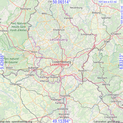
Luxembourg GPS coordinates[2]
49° 36' 42.012" North, 6° 7' 48" East
| Map corner | latitude | longitude |
|---|---|---|
| Upper-left | 50.06514°, | 5.42688° |
| Center: | 49.61167°, | 6.13° |
| Lower-right: | 49.15394°, | 6.83313° |
| Map W x H: | 101.3×101.3 km | = 62.9×62.9mi |
| max Lat: | 50.13722° ⇑63.3% North |
| Luxembourg: | 49.61167° |
| min Lat: | ⇓36.7% South 49.45964° |
| min Long | Luxembourg | max Long |
| 5.76583° | 6.13° | 6.50532° |
| W 53.1%⇐ | ⇒46.9% E |
Elevation
Elevation of Luxembourg is 316 m = 1037 ft, and this is 34 m = 112 ft above average elevation for this country.
| Max E: |
502 m = 1647 ft | 25.4% |
| Luxembourg | 316 m 1037 ft | |
| Avg. | 282 m = 925 ft | |
Min E: |
143 m = 469 ft | 74.6% |
See also: Luxembourg elevation on elevation.city.
Geographical zone
Luxembourg is located in North temperate zone (between Tropic of Cancer and the Arctic Circle). Distance of this North polar circle is 1884.9 km =1171.2 mi to North.| Distance of | km | miles | from Luxembourg |
|---|---|---|---|
| North Pole | 4490.8 | 2790.5 | to North |
| Arctic Circle | 1884.9 | 1171.2 | to North |
| Tropic Cancer | 2910.4 | 1808.4 | to South |
| Equator | 5516.3 | 3427.7 | to South |


Nearby cities:
15 places around Luxembourg: (largest is in red/bold)
• Alzingen
5.7 km =3.5 mi,  154°
154°
• Bertrange
5.8 km =3.6 mi,  269°
269°
• Bridel
6.1 km =3.8 mi,  323°
323°
• Béreldange
4.9 km =3 mi,  350°
350°
• Fentange
5.7 km =3.5 mi,  162°
162°
• Heisdorf
6.8 km =4.2 mi,  7°
7°
• Helmsange
4.6 km =2.9 mi, 10°
• Hesperange
5.1 km =3.2 mi, 162°
• Itzig
4 km =2.5 mi,  132°
132°
• Kirchberg
2 km =1.2 mi,  45°
45°
• Kopstal
7.2 km =4.5 mi,  325°
325°
• Leudelange
6.7 km =4.2 mi,  224°
224°
• Sandweiler
6.7 km =4.2 mi,  87°
87°
• Strassen
4.2 km =2.6 mi,  283°
283°
• Walferdange
5.7 km =3.5 mi,  1°
1°
In other languages:
- In Spanish: Luxemburgo, Ciudad de Luxemburgo
- In German: Luxemburg, Stadt Luxemburg
- In Italian: Lussemburgo
- In Russian: Люксембург
- In Chinese: 盧森堡市
Sources, notices
• [Note1] Compared only with cities in Luxembourg existing in our database
• [Src1] Map data: © OpenStreetMap contributors (CC-BY-SA)
• [Src2] Other city data from geonames.org with taken over terms of usage.
• [Src3] Geographical zone / Annual Mean Temperature by Robert A. Rohde @ Wikipedia
