Smiltene geodata
Smiltene is a seat of a first-order administrative division; located in Latvia in Europe/Riga (GMT+3) time zone. With population of 6,108 people, there are 34 cities with bigger population in this country. Compared to other cities in Latvia, 87.1% of cities are located further ↓South; 77.9% of cities are located further ←West and 74.3% of cities have lower elevation than Smiltene. Note1


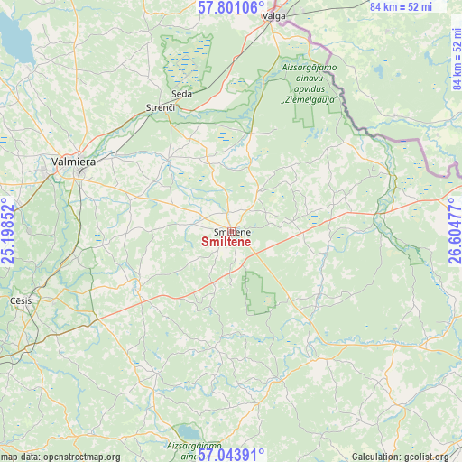
Smiltene GPS coordinates[2]
57° 25' 27.984" North, 25° 54' 5.904" East
| Map corner | latitude | longitude |
|---|---|---|
| Upper-left | 57.80106°, | 25.19852° |
| Center: | 57.42444°, | 25.90164° |
| Lower-right: | 57.04391°, | 26.60477° |
| Map W x H: | 84.2×84.2 km | = 52.3×52.3mi |
| max Lat: | 57.89752° ⇑12.9% North |
| Smiltene: | 57.42444° |
| min Lat: | ⇓87.1% South 55.75284° |
| min Long | Smiltene | max Long |
| 21.01085° | 25.90164° | 28.12165° |
| W 77.9%⇐ | ⇒22.1% E |
Elevation
Elevation of Smiltene is 98 m = 322 ft, and this is 32.6 m = 107 ft above average elevation for this country.
| Max E: |
212 m = 696 ft | 25.7% |
| Smiltene | 98 m 322 ft | |
| Avg. | 65.4 m = 215 ft | |
Min E: |
2 m = 7 ft | 74.3% |
See also: Latvia elevation on elevation.city.
Geographical zone
Smiltene is located in North temperate zone (between Tropic of Cancer and the Arctic Circle). Distance of this North polar circle is 1016.2 km =631.4 mi to North.| Distance of | km | miles | from Smiltene |
|---|---|---|---|
| North Pole | 3622.1 | 2250.7 | to North |
| Arctic Circle | 1016.2 | 631.4 | to North |
| Tropic Cancer | 3779.1 | 2348.2 | to South |
| Equator | 6385 | 3967.5 | to South |


Nearby cities:
15 places around Smiltene: (largest is in red/bold)
• Ape
49 km =30.4 mi,  74°
74°
• Cēsis
39.6 km =24.6 mi,  251°
251°
• Drabeši
42.5 km =26.4 mi,  241°
241°
• Jaunpiebalga
28.5 km =17.7 mi,  164°
164°
• Kocēni
35.3 km =21.9 mi,  287°
287°
• Matīši
53.8 km =33.4 mi,  304°
304°
• Mūrmuiža
25.1 km =15.6 mi,  282°
282°
• Priekuļi
34.6 km =21.5 mi, 249°
• Rauna
20.3 km =12.6 mi, 239°
• Seda
26.7 km =16.6 mi,  340°
340°
• Stalbe
52.5 km =32.6 mi,  263°
263°
• Strenči
25.8 km =16 mi,  330°
330°
• Valka
39.5 km =24.5 mi,  9°
9°
• Valmiera
31.2 km =19.4 mi, 294°
• Vecpiebalga
40.7 km =25.3 mi,  187°
187°
Sources, notices
• [Note1] Compared only with cities in Latvia existing in our database
• [Src1] Map data: © OpenStreetMap contributors (CC-BY-SA)
• [Src2] Other city data from geonames.org with taken over terms of usage.
• [Src3] Geographical zone / Annual Mean Temperature by Robert A. Rohde @ Wikipedia
