Seda geodata
Seda (Strenči) is a populated place; located in Latvia in Europe/Riga (GMT+3) time zone. With population of 1,778 people, there are 82 cities with bigger population in this country. Compared to other cities in Latvia, 93.6% of cities are located further ↓South; 74.3% of cities are located further ←West and 52.9% of cities have higher elevation than Seda. Note1


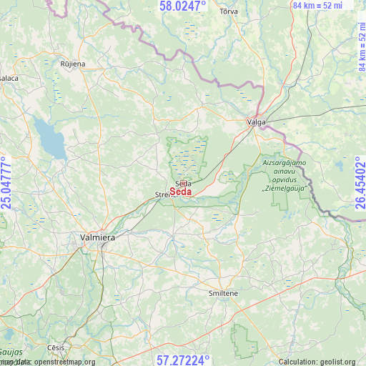
Seda GPS coordinates[2]
57° 39' 1.512" North, 25° 45' 3.204" East
| Map corner | latitude | longitude |
|---|---|---|
| Upper-left | 58.0247°, | 25.04777° |
| Center: | 57.65042°, | 25.75089° |
| Lower-right: | 57.27224°, | 26.45402° |
| Map W x H: | 83.7×83.7 km | = 52×52mi |
| max Lat: | 57.89752° ⇑6.4% North |
| Seda: | 57.65042° |
| min Lat: | ⇓93.6% South 55.75284° |
| min Long | Seda | max Long |
| 21.01085° | 25.75089° | 28.12165° |
| W 74.3%⇐ | ⇒25.7% E |
Elevation
Elevation of Seda is 54 m = 177 ft, and this is 11.4 m = 37 ft below average elevation for this country.
| Max E: |
212 m = 696 ft | 52.9% |
| Avg. | 65.4 m = 215 ft | |
| Seda | 54 m = 177 ft | |
Min E: |
2 m = 7 ft | 47.1% |
See also: Latvia elevation on elevation.city.
Geographical zone
Seda is located in North temperate zone (between Tropic of Cancer and the Arctic Circle). Distance of this North polar circle is 991 km =615.8 mi to North.| Distance of | km | miles | from Seda |
|---|---|---|---|
| North Pole | 3596.9 | 2235 | to North |
| Arctic Circle | 991 | 615.8 | to North |
| Tropic Cancer | 3804.2 | 2363.8 | to South |
| Equator | 6410.1 | 3983.1 | to South |


Nearby cities:
15 places around Seda: (largest is in red/bold)
• Cēsis
47.2 km =29.3 mi,  217°
217°
• Drabeši
53.4 km =33.2 mi,  212°
212°
• Kocēni
28.5 km =17.7 mi,  239°
239°
• Matīši
35.6 km =22.1 mi,  278°
278°
• Mazsalaca
47.6 km =29.6 mi,  299°
299°
• Mūrmuiža
25.1 km =15.6 mi, 218°
• Naukšēni
31.3 km =19.4 mi,  325°
325°
• Priekuļi
44 km =27.3 mi, 211°
• Rauna
36.4 km =22.6 mi,  193°
193°
• Rūjiena
37.1 km =23.1 mi,  317°
317°
• Smiltene
26.7 km =16.6 mi,  160°
160°
• Stalbe
53.1 km =33 mi,  234°
234°
• Strenči
4.8 km =3 mi, 234°
• Valka
20.7 km =12.9 mi,  47°
47°
• Valmiera
22.8 km =14.2 mi, 237°
Sources, notices
• [Note1] Compared only with cities in Latvia existing in our database
• [Src1] Map data: © OpenStreetMap contributors (CC-BY-SA)
• [Src2] Other city data from geonames.org with taken over terms of usage.
• [Src3] Geographical zone / Annual Mean Temperature by Robert A. Rohde @ Wikipedia
