Valka geodata
Valka is a seat of a first-order administrative division; located in Latvia in Europe/Riga (GMT+3) time zone. With population of 6,589 people, there are 33 cities with bigger population in this country. Compared to other cities in Latvia, 96.4% of cities are located further ↓South; 79.3% of cities are located further ←West and 53.6% of cities have higher elevation than Valka. Note1


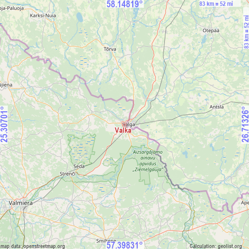
Valka GPS coordinates[2]
57° 46' 30.72" North, 26° 0' 36.468" East
| Map corner | latitude | longitude |
|---|---|---|
| Upper-left | 58.14819°, | 25.30701° |
| Center: | 57.7752°, | 26.01013° |
| Lower-right: | 57.39831°, | 26.71326° |
| Map W x H: | 83.4×83.4 km | = 51.8×51.8mi |
| max Lat: | 57.89752° ⇑3.6% North |
| Valka: | 57.7752° |
| min Lat: | ⇓96.4% South 55.75284° |
| min Long | Valka | max Long |
| 21.01085° | 26.01013° | 28.12165° |
| W 79.3%⇐ | ⇒20.7% E |
Elevation
Elevation of Valka is 53 m = 174 ft, and this is 12.4 m = 41 ft below average elevation for this country.
| Max E: |
212 m = 696 ft | 53.6% |
| Avg. | 65.4 m = 215 ft | |
| Valka | 53 m = 174 ft | |
Min E: |
2 m = 7 ft | 46.4% |
See also: Latvia elevation on elevation.city.
Geographical zone
Valka is located in North temperate zone (between Tropic of Cancer and the Arctic Circle). Distance of this North polar circle is 977.2 km =607.2 mi to North.| Distance of | km | miles | from Valka |
|---|---|---|---|
| North Pole | 3583.1 | 2226.4 | to North |
| Arctic Circle | 977.2 | 607.2 | to North |
| Tropic Cancer | 3818.1 | 2372.5 | to South |
| Equator | 6424 | 3991.7 | to South |


Nearby cities:
15 places around Valka: (largest is in red/bold)
• Aloja
67.2 km =41.8 mi,  269°
269°
• Ape
48.3 km =30 mi,  122°
122°
• Jaunpiebalga
66.5 km =41.3 mi,  179°
179°
• Kocēni
49 km =30.4 mi,  234°
234°
• Matīši
51.2 km =31.8 mi,  260°
260°
• Mazsalaca
57.4 km =35.7 mi,  279°
279°
• Mūrmuiža
45.6 km =28.3 mi,  222°
222°
• Naukšēni
34.9 km =21.7 mi,  290°
290°
• Priekuļi
64.2 km =39.9 mi, 217°
• Rauna
54.8 km =34.1 mi,  205°
205°
• Rūjiena
42.4 km =26.3 mi, 288°
• Seda
20.7 km =12.9 mi, 227°
• Smiltene
39.5 km =24.5 mi,  189°
189°
• Strenči
25.5 km =15.8 mi, 229°
• Valmiera
43.3 km =26.9 mi, 233°
Sources, notices
• [Note1] Compared only with cities in Latvia existing in our database
• [Src1] Map data: © OpenStreetMap contributors (CC-BY-SA)
• [Src2] Other city data from geonames.org with taken over terms of usage.
• [Src3] Geographical zone / Annual Mean Temperature by Robert A. Rohde @ Wikipedia
