Mazsalaca geodata
Mazsalaca is a seat of a first-order administrative division; located in Latvia in Europe/Riga (GMT+3) time zone. With population of 2,412 people, there are 64 cities with bigger population in this country. Compared to other cities in Latvia, 97.9% of cities are located further ↓South; 59.3% of cities are located further ←West and 51.4% of cities have lower elevation than Mazsalaca. Note1


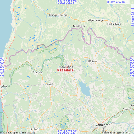
Mazsalaca GPS coordinates[2]
57° 51' 47.844" North, 25° 3' 17.1" East
| Map corner | latitude | longitude |
|---|---|---|
| Upper-left | 58.23537°, | 24.35163° |
| Center: | 57.86329°, | 25.05475° |
| Lower-right: | 57.48732°, | 25.75788° |
| Map W x H: | 83.2×83.2 km | = 51.7×51.7mi |
| max Lat: | 57.89752° ⇑2.1% North |
| Mazsalaca: | 57.86329° |
| min Lat: | ⇓97.9% South 55.75284° |
| min Long | Mazsalaca | max Long |
| 21.01085° | 25.05475° | 28.12165° |
| W 59.3%⇐ | ⇒40.7% E |
Elevation
Elevation of Mazsalaca is 58 m = 190 ft, and this is 7.4 m = 24 ft below average elevation for this country.
| Max E: |
212 m = 696 ft | 48.6% |
| Avg. | 65.4 m = 215 ft | |
| Mazsalaca | 58 m = 190 ft | |
Min E: |
2 m = 7 ft | 51.4% |
See also: Latvia elevation on elevation.city.
Geographical zone
Mazsalaca is located in North temperate zone (between Tropic of Cancer and the Arctic Circle). Distance of this North polar circle is 967.4 km =601.1 mi to North.| Distance of | km | miles | from Mazsalaca |
|---|---|---|---|
| North Pole | 3573.3 | 2220.3 | to North |
| Arctic Circle | 967.4 | 601.1 | to North |
| Tropic Cancer | 3827.9 | 2378.5 | to South |
| Equator | 6433.8 | 3997.8 | to South |


Nearby cities:
15 places around Mazsalaca: (largest is in red/bold)
• Ainaži
41.2 km =25.6 mi,  270°
270°
• Aloja
15 km =9.3 mi,  224°
224°
• Kocēni
41.7 km =25.9 mi,  156°
156°
• Limbaži
43.8 km =27.2 mi,  207°
207°
• Matīši
19.3 km =12 mi, 161°
• Mūrmuiža
50.6 km =31.4 mi,  149°
149°
• Naukšēni
23.8 km =14.8 mi,  84°
84°
• Rūjiena
16.8 km =10.4 mi, 76°
• Salacgrīva
43 km =26.7 mi,  253°
253°
• Seda
47.6 km =29.6 mi,  119°
119°
• Staicele
18.5 km =11.5 mi,  260°
260°
• Stalbe
54.8 km =34.1 mi,  181°
181°
• Strenči
45.8 km =28.5 mi,  125°
125°
• Valka
57.4 km =35.7 mi,  99°
99°
• Valmiera
42.1 km =26.2 mi, 148°
Sources, notices
• [Note1] Compared only with cities in Latvia existing in our database
• [Src1] Map data: © OpenStreetMap contributors (CC-BY-SA)
• [Src2] Other city data from geonames.org with taken over terms of usage.
• [Src3] Geographical zone / Annual Mean Temperature by Robert A. Rohde @ Wikipedia
