Staicele geodata
Staicele (Aloja) is a populated place; located in Latvia in Europe/Riga (GMT+3) time zone. With population of 1,175 people, there are 94 cities with bigger population in this country. Compared to other cities in Latvia, 97.1% of cities are located further ↓South; 53.6% of cities are located further ←West and 55.7% of cities have higher elevation than Staicele. Note1


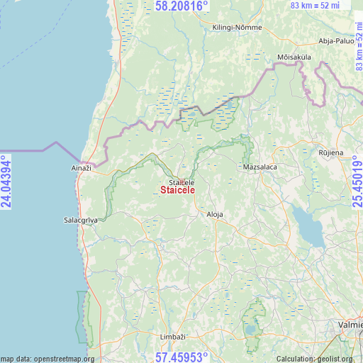
Staicele GPS coordinates[2]
57° 50' 8.844" North, 24° 44' 49.416" East
| Map corner | latitude | longitude |
|---|---|---|
| Upper-left | 58.20816°, | 24.04394° |
| Center: | 57.83579°, | 24.74706° |
| Lower-right: | 57.45953°, | 25.45019° |
| Map W x H: | 83.2×83.2 km | = 51.7×51.7mi |
| max Lat: | 57.89752° ⇑2.9% North |
| Staicele: | 57.83579° |
| min Lat: | ⇓97.1% South 55.75284° |
| min Long | Staicele | max Long |
| 21.01085° | 24.74706° | 28.12165° |
| W 53.6%⇐ | ⇒46.4% E |
Elevation
Elevation of Staicele is 51 m = 167 ft, and this is 14.4 m = 47 ft below average elevation for this country.
| Max E: |
212 m = 696 ft | 55.7% |
| Avg. | 65.4 m = 215 ft | |
| Staicele | 51 m = 167 ft | |
Min E: |
2 m = 7 ft | 44.3% |
See also: Latvia elevation on elevation.city.
Geographical zone
Staicele is located in North temperate zone (between Tropic of Cancer and the Arctic Circle). Distance of this North polar circle is 970.4 km =603 mi to North.| Distance of | km | miles | from Staicele |
|---|---|---|---|
| North Pole | 3576.3 | 2222.2 | to North |
| Arctic Circle | 970.4 | 603 | to North |
| Tropic Cancer | 3824.8 | 2376.6 | to South |
| Equator | 6430.7 | 3995.9 | to South |


Nearby cities:
15 places around Staicele: (largest is in red/bold)
• Ainaži
23.2 km =14.4 mi,  277°
277°
• Aloja
10.9 km =6.8 mi,  134°
134°
• Cēsis
66.2 km =41.1 mi,  151°
151°
• Kocēni
49.6 km =30.8 mi, 134°
• Limbaži
35.9 km =22.3 mi,  182°
182°
• Matīši
28.8 km =17.9 mi,  121°
121°
• Mazsalaca
18.5 km =11.5 mi,  80°
80°
• Mūrmuiža
59.9 km =37.2 mi, 132°
• Naukšēni
42.3 km =26.3 mi, 82°
• Rūjiena
35.2 km =21.9 mi, 78°
• Salacgrīva
24.8 km =15.4 mi,  248°
248°
• Seda
63 km =39.1 mi,  109°
109°
• Stalbe
54.4 km =33.8 mi,  161°
161°
• Strenči
60.4 km =37.5 mi, 112°
• Valmiera
52.1 km =32.4 mi, 129°
Sources, notices
• [Note1] Compared only with cities in Latvia existing in our database
• [Src1] Map data: © OpenStreetMap contributors (CC-BY-SA)
• [Src2] Other city data from geonames.org with taken over terms of usage.
• [Src3] Geographical zone / Annual Mean Temperature by Robert A. Rohde @ Wikipedia
