Dagda geodata
Dagda is a seat of a first-order administrative division; located in Latvia in Europe/Riga (GMT+3) time zone. With population of 2,740 people, there are 57 cities with bigger population in this country. Compared to other cities in Latvia, 96.4% of cities are located further ↑North; 95.7% of cities are located further ←West and 97.9% of cities have lower elevation than Dagda. Note1


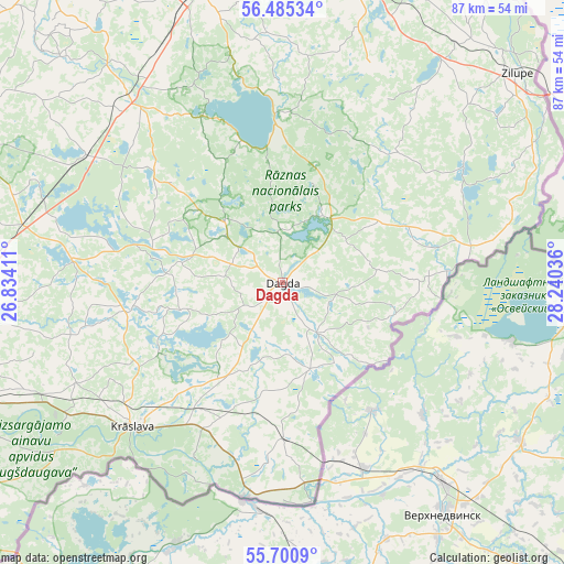
Dagda GPS coordinates[2]
56° 5' 42.432" North, 27° 32' 14.028" East
| Map corner | latitude | longitude |
|---|---|---|
| Upper-left | 56.48534°, | 26.83411° |
| Center: | 56.09512°, | 27.53723° |
| Lower-right: | 55.7009°, | 28.24036° |
| Map W x H: | 87.2×87.2 km | = 54.2×54.2mi |
| max Lat: | 57.89752° ⇑96.4% North |
| Dagda: | 56.09512° |
| min Lat: | ⇓3.6% South 55.75284° |
| min Long | Dagda | max Long |
| 21.01085° | 27.53723° | 28.12165° |
| W 95.7%⇐ | ⇒4.3% E |
Elevation
Elevation of Dagda is 171 m = 561 ft, and this is 105.6 m = 346 ft above average elevation for this country.
| Max E: |
212 m = 696 ft | 2.1% |
| Dagda | 171 m 561 ft | |
| Avg. | 65.4 m = 215 ft | |
Min E: |
2 m = 7 ft | 97.9% |
See also: Latvia elevation on elevation.city.
Geographical zone
Dagda is located in North temperate zone (between Tropic of Cancer and the Arctic Circle). Distance of this North polar circle is 1164 km =723.3 mi to North.| Distance of | km | miles | from Dagda |
|---|---|---|---|
| North Pole | 3769.9 | 2342.5 | to North |
| Arctic Circle | 1164 | 723.3 | to North |
| Tropic Cancer | 3631.3 | 2256.4 | to South |
| Equator | 6237.2 | 3875.6 | to South |


Nearby cities:
15 places around Dagda: (largest is in red/bold)
• Aglona
33.1 km =20.6 mi,  277°
277°
• Cibla
54.9 km =34.1 mi,  22°
22°
• Daugavpils
66.7 km =41.4 mi,  249°
249°
• Jaunaglona
33.6 km =20.9 mi, 282°
• Krāslava
32 km =19.9 mi,  225°
225°
• Kārsava
77.2 km =48 mi,  6°
6°
• Ludza
50.7 km =31.5 mi, 12°
• Preiļi
54.9 km =34.1 mi,  293°
293°
• Riebiņi
53.3 km =33.1 mi,  301°
301°
• Rēzekne
47.7 km =29.6 mi,  345°
345°
• Silene
60.4 km =37.5 mi, 230°
• Varakļāni
74.7 km =46.4 mi,  319°
319°
• Vecvārkava
64.8 km =40.3 mi, 280°
• Viļāni
63.4 km =39.4 mi, 323°
• Zilupe
48.5 km =30.1 mi,  48°
48°
Sources, notices
• [Note1] Compared only with cities in Latvia existing in our database
• [Src1] Map data: © OpenStreetMap contributors (CC-BY-SA)
• [Src2] Other city data from geonames.org with taken over terms of usage.
• [Src3] Geographical zone / Annual Mean Temperature by Robert A. Rohde @ Wikipedia
