Preiļi geodata
Preiļi (Preiļu novads) is a seat of a first-order administrative division; located in Latvia in Europe/Riga (GMT+3) time zone. With population of 8,656 people, there are 29 cities with bigger population in this country. Compared to other cities in Latvia, 91.4% of cities are located further ↑North; 86.4% of cities are located further ←West and 87.9% of cities have lower elevation than Preiļi. Note1


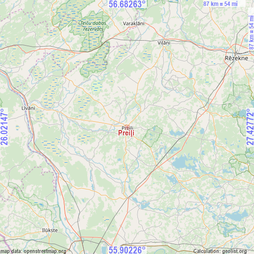
Preiļi GPS coordinates[2]
56° 17' 39.984" North, 26° 43' 28.524" East
| Map corner | latitude | longitude |
|---|---|---|
| Upper-left | 56.68263°, | 26.02147° |
| Center: | 56.29444°, | 26.72459° |
| Lower-right: | 55.90226°, | 27.42772° |
| Map W x H: | 86.8×86.8 km | = 53.9×53.9mi |
| max Lat: | 57.89752° ⇑91.4% North |
| Preiļi: | 56.29444° |
| min Lat: | ⇓8.6% South 55.75284° |
| min Long | Preiļi | max Long |
| 21.01085° | 26.72459° | 28.12165° |
| W 86.4%⇐ | ⇒13.6% E |
Elevation
Elevation of Preiļi is 127 m = 417 ft, and this is 61.6 m = 202 ft above average elevation for this country.
| Max E: |
212 m = 696 ft | 12.1% |
| Preiļi | 127 m 417 ft | |
| Avg. | 65.4 m = 215 ft | |
Min E: |
2 m = 7 ft | 87.9% |
See also: Latvia elevation on elevation.city.
Geographical zone
Preiļi is located in North temperate zone (between Tropic of Cancer and the Arctic Circle). Distance of this North polar circle is 1141.8 km =709.5 mi to North.| Distance of | km | miles | from Preiļi |
|---|---|---|---|
| North Pole | 3747.7 | 2328.7 | to North |
| Arctic Circle | 1141.8 | 709.5 | to North |
| Tropic Cancer | 3653.4 | 2270.1 | to South |
| Equator | 6259.4 | 3889.4 | to South |


Nearby cities:
15 places around Preiļi: (largest is in red/bold)
• Aglona
25.1 km =15.6 mi,  135°
135°
• Dagda
54.9 km =34.1 mi,  113°
113°
• Daugavpils
47.2 km =29.3 mi,  194°
194°
• Ilūkste
44.1 km =27.4 mi,  216°
216°
• Jaunaglona
22.9 km =14.2 mi,  130°
130°
• Jēkabpils
58 km =36 mi,  293°
293°
• Krustpils
58.3 km =36.2 mi, 294°
• Krāslava
52.2 km =32.4 mi,  148°
148°
• Līvāni
34.5 km =21.4 mi,  281°
281°
• Riebiņi
7.1 km =4.4 mi,  40°
40°
• Rēzekne
44.8 km =27.8 mi,  57°
57°
• Subate
59.9 km =37.2 mi,  237°
237°
• Varakļāni
34.9 km =21.7 mi,  2°
2°
• Vecvārkava
17.1 km =10.6 mi,  231°
231°
• Viļāni
31.2 km =19.4 mi,  23°
23°
Sources, notices
• [Note1] Compared only with cities in Latvia existing in our database
• [Src1] Map data: © OpenStreetMap contributors (CC-BY-SA)
• [Src2] Other city data from geonames.org with taken over terms of usage.
• [Src3] Geographical zone / Annual Mean Temperature by Robert A. Rohde @ Wikipedia
