Jaunaglona geodata
Jaunaglona (Preiļu novads) is a populated place; located in Latvia in Europe/Riga (GMT+3) time zone. With population of 1,053 people, there are 97 cities with bigger population in this country. Compared to other cities in Latvia, 95% of cities are located further ↑North; 91.4% of cities are located further ←West and 90.7% of cities have lower elevation than Jaunaglona. Note1


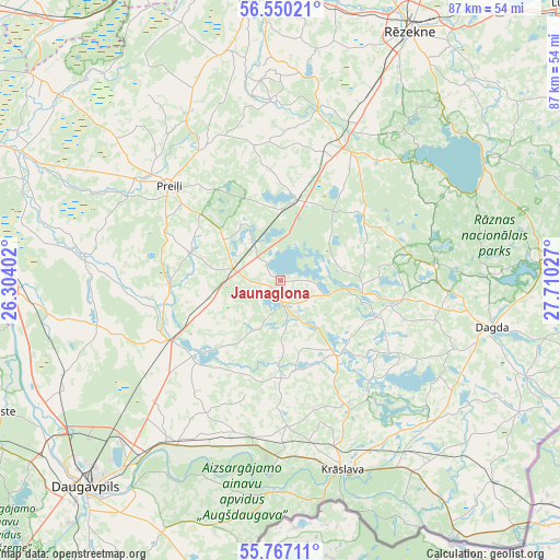
Jaunaglona GPS coordinates[2]
56° 9' 38.376" North, 27° 0' 25.704" East
| Map corner | latitude | longitude |
|---|---|---|
| Upper-left | 56.55021°, | 26.30402° |
| Center: | 56.16066°, | 27.00714° |
| Lower-right: | 55.76711°, | 27.71027° |
| Map W x H: | 87.1×87.1 km | = 54.1×54.1mi |
| max Lat: | 57.89752° ⇑95% North |
| Jaunaglona: | 56.16066° |
| min Lat: | ⇓5% South 55.75284° |
| min Long | Jaunaglona | max Long |
| 21.01085° | 27.00714° | 28.12165° |
| W 91.4%⇐ | ⇒8.6% E |
Elevation
Elevation of Jaunaglona is 146 m = 479 ft, and this is 80.6 m = 264 ft above average elevation for this country.
| Max E: |
212 m = 696 ft | 9.3% |
| Jaunaglona | 146 m 479 ft | |
| Avg. | 65.4 m = 215 ft | |
Min E: |
2 m = 7 ft | 90.7% |
See also: Latvia elevation on elevation.city.
Geographical zone
Jaunaglona is located in North temperate zone (between Tropic of Cancer and the Arctic Circle). Distance of this North polar circle is 1156.7 km =718.7 mi to North.| Distance of | km | miles | from Jaunaglona |
|---|---|---|---|
| North Pole | 3762.6 | 2338 | to North |
| Arctic Circle | 1156.7 | 718.7 | to North |
| Tropic Cancer | 3638.6 | 2260.9 | to South |
| Equator | 6244.5 | 3880.2 | to South |


Nearby cities:
15 places around Jaunaglona: (largest is in red/bold)
• Aglona
3.1 km =1.9 mi,  180°
180°
• Cibla
69.2 km =43 mi,  51°
51°
• Dagda
33.6 km =20.9 mi,  102°
102°
• Daugavpils
42.6 km =26.5 mi,  223°
223°
• Ilūkste
48.6 km =30.2 mi,  245°
245°
• Krāslava
31.2 km =19.4 mi,  161°
161°
• Ludza
60.8 km =37.8 mi, 46°
• Līvāni
55.7 km =34.6 mi,  292°
292°
• Preiļi
22.9 km =14.2 mi,  310°
310°
• Riebiņi
24 km =14.9 mi,  327°
327°
• Rēzekne
44 km =27.3 mi,  27°
27°
• Silene
47.4 km =29.5 mi,  196°
196°
• Varakļāni
52.2 km =32.4 mi,  342°
342°
• Vecvārkava
31.2 km =19.4 mi,  277°
277°
• Viļāni
43.9 km =27.3 mi,  353°
353°
Sources, notices
• [Note1] Compared only with cities in Latvia existing in our database
• [Src1] Map data: © OpenStreetMap contributors (CC-BY-SA)
• [Src2] Other city data from geonames.org with taken over terms of usage.
• [Src3] Geographical zone / Annual Mean Temperature by Robert A. Rohde @ Wikipedia
