Aglona geodata
Aglona is a seat of a first-order administrative division; located in Latvia in Europe/Riga (GMT+3) time zone. In our database, there are 110 cities with bigger population. Compared to other cities in Latvia, 95.7% of cities are located further ↑North; 90.7% of cities are located further ←West and 93.6% of cities have lower elevation than Aglona. Note1


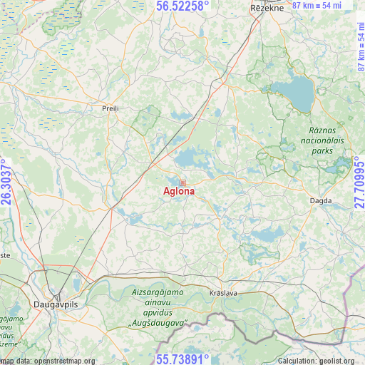
Aglona GPS coordinates[2]
56° 7' 57.864" North, 27° 0' 24.552" East
| Map corner | latitude | longitude |
|---|---|---|
| Upper-left | 56.52258°, | 26.3037° |
| Center: | 56.13274°, | 27.00682° |
| Lower-right: | 55.73891°, | 27.70995° |
| Map W x H: | 87.1×87.1 km | = 54.1×54.1mi |
| max Lat: | 57.89752° ⇑95.7% North |
| Aglona: | 56.13274° |
| min Lat: | ⇓4.3% South 55.75284° |
| min Long | Aglona | max Long |
| 21.01085° | 27.00682° | 28.12165° |
| W 90.7%⇐ | ⇒9.3% E |
Elevation
Elevation of Aglona is 150 m = 492 ft, and this is 84.6 m = 278 ft above average elevation for this country.
| Max E: |
212 m = 696 ft | 6.4% |
| Aglona | 150 m 492 ft | |
| Avg. | 65.4 m = 215 ft | |
Min E: |
2 m = 7 ft | 93.6% |
See also: Latvia elevation on elevation.city.
Geographical zone
Aglona is located in North temperate zone (between Tropic of Cancer and the Arctic Circle). Distance of this North polar circle is 1159.8 km =720.7 mi to North.| Distance of | km | miles | from Aglona |
|---|---|---|---|
| North Pole | 3765.7 | 2339.9 | to North |
| Arctic Circle | 1159.8 | 720.7 | to North |
| Tropic Cancer | 3635.5 | 2259 | to South |
| Equator | 6241.4 | 3878.2 | to South |


Nearby cities:
15 places around Aglona: (largest is in red/bold)
• Dagda
33.1 km =20.6 mi,  97°
97°
• Daugavpils
40.4 km =25.1 mi,  226°
226°
• Ilūkste
47.4 km =29.5 mi,  248°
248°
• Jaunaglona
3.1 km =1.9 mi,  0°
0°
• Krāslava
28.3 km =17.6 mi,  159°
159°
• Ludza
63 km =39.1 mi,  44°
44°
• Līvāni
56.9 km =35.4 mi,  295°
295°
• Preiļi
25.1 km =15.6 mi,  315°
315°
• Riebiņi
26.6 km =16.5 mi,  331°
331°
• Rēzekne
46.7 km =29 mi,  26°
26°
• Silene
44.4 km =27.6 mi,  198°
198°
• Subate
69.7 km =43.3 mi,  258°
258°
• Varakļāni
55.1 km =34.2 mi,  343°
343°
• Vecvārkava
31.7 km =19.7 mi,  283°
283°
• Viļāni
47 km =29.2 mi,  353°
353°
Sources, notices
• [Note1] Compared only with cities in Latvia existing in our database
• [Src1] Map data: © OpenStreetMap contributors (CC-BY-SA)
• [Src2] Other city data from geonames.org with taken over terms of usage.
• [Src3] Geographical zone / Annual Mean Temperature by Robert A. Rohde @ Wikipedia
