Līvāni geodata
Līvāni is a seat of a first-order administrative division; located in Latvia in Europe/Riga (GMT+3) time zone. With population of 10,073 people, there are 23 cities with bigger population in this country. Compared to other cities in Latvia, 88.6% of cities are located further ↑North; 80.7% of cities are located further ←West and 70.7% of cities have lower elevation than Līvāni. Note1


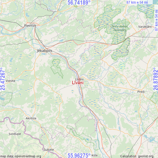
Līvāni GPS coordinates[2]
56° 21' 15.516" North, 26° 10' 32.844" East
| Map corner | latitude | longitude |
|---|---|---|
| Upper-left | 56.74189°, | 25.47267° |
| Center: | 56.35431°, | 26.17579° |
| Lower-right: | 55.96275°, | 26.87892° |
| Map W x H: | 86.6×86.6 km | = 53.8×53.8mi |
| max Lat: | 57.89752° ⇑88.6% North |
| Līvāni: | 56.35431° |
| min Lat: | ⇓11.4% South 55.75284° |
| min Long | Līvāni | max Long |
| 21.01085° | 26.17579° | 28.12165° |
| W 80.7%⇐ | ⇒19.3% E |
Elevation
Elevation of Līvāni is 92 m = 302 ft, and this is 26.6 m = 87 ft above average elevation for this country.
| Max E: |
212 m = 696 ft | 29.3% |
| Līvāni | 92 m 302 ft | |
| Avg. | 65.4 m = 215 ft | |
Min E: |
2 m = 7 ft | 70.7% |
See also: Latvia elevation on elevation.city.
Geographical zone
Līvāni is located in North temperate zone (between Tropic of Cancer and the Arctic Circle). Distance of this North polar circle is 1135.2 km =705.4 mi to North.| Distance of | km | miles | from Līvāni |
|---|---|---|---|
| North Pole | 3741.1 | 2324.6 | to North |
| Arctic Circle | 1135.2 | 705.4 | to North |
| Tropic Cancer | 3660.1 | 2274.3 | to South |
| Equator | 6266 | 3893.5 | to South |


Nearby cities:
15 places around Līvāni: (largest is in red/bold)
• Aknīste
34 km =21.1 mi,  230°
230°
• Ilūkste
42.6 km =26.5 mi,  169°
169°
• Jaunaglona
55.7 km =34.6 mi,  112°
112°
• Jēkabpils
25.3 km =15.7 mi,  309°
309°
• Krustpils
26 km =16.2 mi, 311°
• Madona
55.5 km =34.5 mi,  2°
2°
• Preiļi
34.5 km =21.4 mi,  101°
101°
• Pļaviņas
40.3 km =25 mi,  316°
316°
• Riebiņi
38.5 km =23.9 mi,  91°
91°
• Sala
30.5 km =19 mi,  303°
303°
• Subate
42.1 km =26.2 mi,  203°
203°
• Varakļāni
45.4 km =28.2 mi,  51°
51°
• Vecvārkava
26.9 km =16.7 mi,  130°
130°
• Viesīte
38.2 km =23.7 mi,  268°
268°
• Viļāni
51 km =31.7 mi,  64°
64°
Sources, notices
• [Note1] Compared only with cities in Latvia existing in our database
• [Src1] Map data: © OpenStreetMap contributors (CC-BY-SA)
• [Src2] Other city data from geonames.org with taken over terms of usage.
• [Src3] Geographical zone / Annual Mean Temperature by Robert A. Rohde @ Wikipedia
