Ghadāmis geodata
Ghadāmis (Nālūt) is a populated place; located in Libya in Africa/Tripoli (GMT+2) time zone. With population of 7,000 people, there are 44 cities with bigger population in this country. Compared to other cities in Libya, 69.8% of cities are located further ↑North; 100% of cities are located further →East and 64.2% of cities have lower elevation than Ghadāmis. Note1


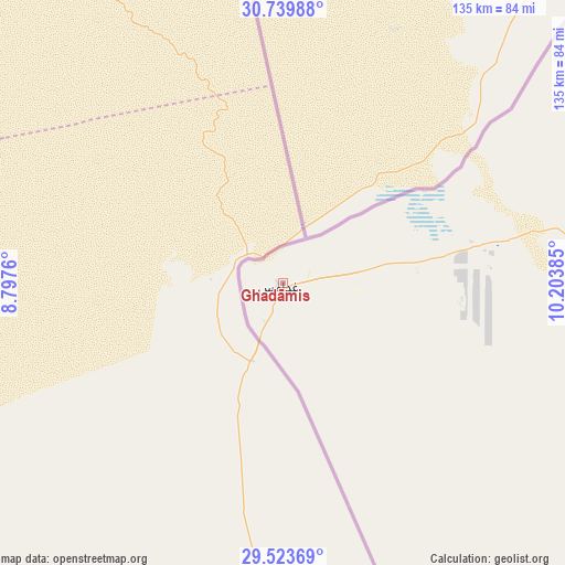
Ghadāmis GPS coordinates[2]
30° 8' 1.176" North, 9° 30' 2.592" East
| Map corner | latitude | longitude |
|---|---|---|
| Upper-left | 30.73988°, | 8.7976° |
| Center: | 30.13366°, | 9.50072° |
| Lower-right: | 29.52369°, | 10.20385° |
| Map W x H: | 135.2×135.2 km | = 84×84mi |
| max Lat: | 32.94699° ⇑69.8% North |
| Ghadāmis: | 30.13366° |
| min Lat: | ⇓30.2% South 24.1989° |
| min Long | Ghadāmis | max Long |
| 9.50072° | 9.50072° | 25.0866° |
| W 0%⇐ | ⇒100% E |
Elevation
Elevation of Ghadāmis is 339 m = 1112 ft, and this is 106.8 m = 350 ft above average elevation for this country.
| Max E: |
704 m = 2310 ft | 35.8% |
| Ghadāmis | 339 m 1112 ft | |
| Avg. | 232.2 m = 762 ft | |
Min E: |
3 m = 10 ft | 64.2% |
See also: Libya elevation on elevation.city.
Geographical zone
Ghadāmis is located in North temperate zone (between Tropic of Cancer and the Arctic Circle). Distance of this Northern Tropic circle is 744.6 km =462.7 mi to South.| Distance of | km | miles | from Ghadāmis |
|---|---|---|---|
| North Pole | 6656.5 | 4136.2 | to North |
| Arctic Circle | 4050.6 | 2516.9 | to North |
| Tropic Cancer | 744.6 | 462.7 | to South |
| Equator | 3350.5 | 2081.9 | to South |


Nearby cities:
8 places around Ghadāmis: (largest is in red/bold)
• Al Ajaylat
399.3 km =248.1 mi,  43°
43°
• Giado
314.7 km =195.5 mi,  49°
49°
• Mizdah
363.5 km =225.9 mi,  66°
66°
• Nālūt
239 km =148.5 mi, 36°
• Yafran
359.3 km =223.3 mi, 53°
• Zalţan
384.8 km =239.1 mi, 35°
• Zintan
329.7 km =204.9 mi, 52°
• Zuwārah
395.7 km =245.9 mi, 38°
In other languages:
- In Spanish: Gadamés
- In German: Ghadames
- In Italian: Ghadames
- In Russian: Гадамес
Sources, notices
• [Note1] Compared only with cities in Libya existing in our database
• [Src1] Map data: © OpenStreetMap contributors (CC-BY-SA)
• [Src2] Other city data from geonames.org with taken over terms of usage.
• [Src3] Geographical zone / Annual Mean Temperature by Robert A. Rohde @ Wikipedia
