Yafran geodata
Yafran (Jabal al Gharbi) is a populated place; located in Libya in Africa/Tripoli (GMT+2) time zone. With population of 67,638 people, there are 20 cities with bigger population in this country. Compared to other cities in Libya, 54.7% of cities are located further ↓South; 83% of cities are located further →East and 94.3% of cities have lower elevation than Yafran. Note1


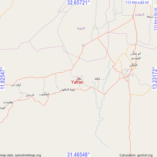
Yafran GPS coordinates[2]
32° 3' 47.844" North, 12° 31' 42.924" East
| Map corner | latitude | longitude |
|---|---|---|
| Upper-left | 32.65721°, | 11.82547° |
| Center: | 32.06329°, | 12.52859° |
| Lower-right: | 31.46548°, | 13.23172° |
| Map W x H: | 132.5×132.5 km | = 82.3×82.3mi |
| max Lat: | 32.94699° ⇑45.3% North |
| Yafran: | 32.06329° |
| min Lat: | ⇓54.7% South 24.1989° |
| min Long | Yafran | max Long |
| 9.50072° | 12.52859° | 25.0866° |
| W 17%⇐ | ⇒83% E |
Elevation
Elevation of Yafran is 681 m = 2234 ft, and this is 448.8 m = 1472 ft above average elevation for this country.
| Max E: |
704 m = 2310 ft | 5.7% |
| Yafran | 681 m 2234 ft | |
| Avg. | 232.2 m = 762 ft | |
Min E: |
3 m = 10 ft | 94.3% |
See also: Yafran elevation on elevation.city.
Geographical zone
Yafran is located in North temperate zone (between Tropic of Cancer and the Arctic Circle). Distance of this Northern Tropic circle is 959.2 km =596 mi to South.| Distance of | km | miles | from Yafran |
|---|---|---|---|
| North Pole | 6442 | 4002.9 | to North |
| Arctic Circle | 3836.1 | 2383.6 | to North |
| Tropic Cancer | 959.2 | 596 | to South |
| Equator | 3565.1 | 2215.2 | to South |


Nearby cities:
15 places around Yafran: (largest is in red/bold)
• Al Ajaylat
78.5 km =48.8 mi,  349°
349°
• Al ‘Azīzīyah
69.5 km =43.2 mi,  41°
41°
• Az Zāwīyah
79.4 km =49.3 mi,  13°
13°
• Gharyan
47.9 km =29.8 mi,  75°
75°
• Giado
48.6 km =30.2 mi,  255°
255°
• Mizdah
80.8 km =50.2 mi,  147°
147°
• Tagiura
119.3 km =74.1 mi, 40°
• Tarhuna
111.8 km =69.5 mi,  68°
68°
• Tripoli
110.5 km =68.7 mi,  33°
33°
• Zalţan
116.2 km =72.2 mi,  327°
327°
• Zawiya
78.9 km =49 mi, 13°
• Zintan
29.8 km =18.5 mi,  240°
240°
• Zuwārah
105.2 km =65.4 mi,  336°
336°
• Şabrātah
81.3 km =50.5 mi,  357°
357°
• Şurmān
77.2 km =48 mi,  2°
2°
Sources, notices
• [Note1] Compared only with cities in Libya existing in our database
• [Src1] Map data: © OpenStreetMap contributors (CC-BY-SA)
• [Src2] Other city data from geonames.org with taken over terms of usage.
• [Src3] Geographical zone / Annual Mean Temperature by Robert A. Rohde @ Wikipedia
