Zagora geodata
Zagora (Drâa-Tafilalet) is a seat of a third-order administrative division; located in Morocco in Africa/Casablanca (GMT+1) time zone. With population of 35,154 people, there are 65 cities with bigger population in this country. Compared to other cities in Morocco, 91.9% of cities are located further ↑North; 53.1% of cities are located further ←West and 61.6% of cities have lower elevation than Zagora. Note1


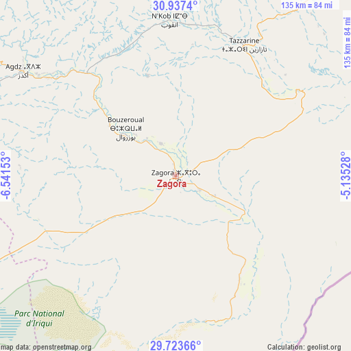
Zagora GPS coordinates[2]
30° 19' 56.676" North, 5° 50' 18.24" West
| Map corner | latitude | longitude |
|---|---|---|
| Upper-left | 30.9374°, | -6.54153° |
| Center: | 30.33241°, | -5.8384° |
| Lower-right: | 29.72366°, | -5.13528° |
| Map W x H: | 135×135 km | = 83.9×83.9mi |
| max Lat: | 35.84906° ⇑91.9% North |
| Zagora: | 30.33241° |
| min Lat: | ⇓8.1% South 22.6558° |
| min Long | Zagora | max Long |
| -15.60719° | -5.8384° | -1.22855° |
| W 53.1%⇐ | ⇒46.9% E |
Elevation
Elevation of Zagora is 733 m = 2405 ft, and this is 116.2 m = 381 ft above average elevation for this country.
| Max E: |
2637 m = 8652 ft | 38.4% |
| Zagora | 733 m 2405 ft | |
| Avg. | 616.8 m = 2024 ft | |
Min E: |
1 m = 3 ft | 61.6% |
See also: Morocco elevation on elevation.city.
Geographical zone
Zagora is located in North temperate zone (between Tropic of Cancer and the Arctic Circle). Distance of this Northern Tropic circle is 766.7 km =476.4 mi to South.| Distance of | km | miles | from Zagora |
|---|---|---|---|
| North Pole | 6634.4 | 4122.4 | to North |
| Arctic Circle | 4028.5 | 2503.2 | to North |
| Tropic Cancer | 766.7 | 476.4 | to South |
| Equator | 3372.6 | 2095.6 | to South |


Nearby cities:
15 places around Zagora: (largest is in red/bold)
• Agdz
70.7 km =43.9 mi,  304°
304°
• Alnif
107.8 km =67 mi,  36°
36°
• Amerzgane
153.2 km =95.2 mi, 301°
• Ifrane
159.9 km =99.4 mi,  342°
342°
• Imider
115.8 km =72 mi,  2°
2°
• Jebel Tiskaouine
103.6 km =64.4 mi, 41°
• Kelaat Mgouna
105.4 km =65.5 mi, 344°
• Mhamid
58.1 km =36.1 mi,  168°
168°
• Ouarzazat
120.2 km =74.7 mi, 302°
• Skoura
106.1 km =65.9 mi,  319°
319°
• Tabant
156.6 km =97.3 mi, 339°
• Taznakht
133.7 km =83.1 mi,  281°
281°
• Telouet
170.8 km =106.1 mi,  308°
308°
• Tilmi
165.3 km =102.7 mi, 2°
• Tinghir
134.7 km =83.7 mi,  12°
12°
Sources, notices
• [Note1] Compared only with cities in Morocco existing in our database
• [Src1] Map data: © OpenStreetMap contributors (CC-BY-SA)
• [Src2] Other city data from geonames.org with taken over terms of usage.
• [Src3] Geographical zone / Annual Mean Temperature by Robert A. Rohde @ Wikipedia
