Mhamid geodata
Mhamid (Drâa-Tafilalet) is a populated place; located in Morocco in Africa/Casablanca (GMT+1) time zone. With population of 10,000 people, there are 90 cities with bigger population in this country. Compared to other cities in Morocco, 94.2% of cities are located further ↑North; 55.4% of cities are located further ←West and 55% of cities have lower elevation than Mhamid. Note1


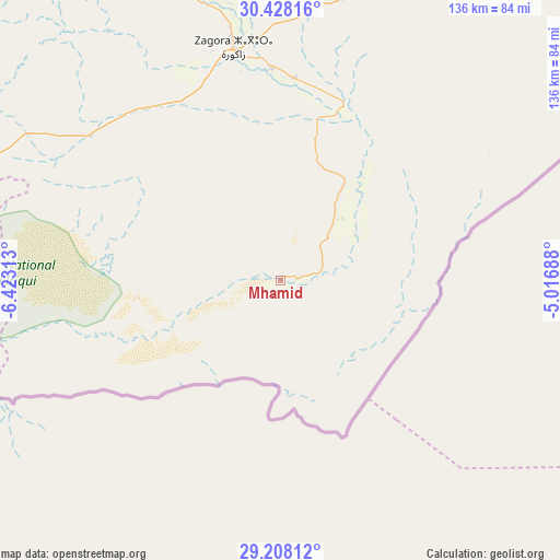
Mhamid GPS coordinates[2]
29° 49' 12" North, 5° 43' 12" West
| Map corner | latitude | longitude |
|---|---|---|
| Upper-left | 30.42816°, | -6.42313° |
| Center: | 29.82°, | -5.72° |
| Lower-right: | 29.20812°, | -5.01688° |
| Map W x H: | 135.7×135.7 km | = 84.3×84.3mi |
| max Lat: | 35.84906° ⇑94.2% North |
| Mhamid: | 29.82° |
| min Lat: | ⇓5.8% South 22.6558° |
| min Long | Mhamid | max Long |
| -15.60719° | -5.72° | -1.22855° |
| W 55.4%⇐ | ⇒44.6% E |
Elevation
Elevation of Mhamid is 550 m = 1804 ft, and this is 66.8 m = 219 ft below average elevation for this country.
| Max E: |
2637 m = 8652 ft | 45% |
| Avg. | 616.8 m = 2024 ft | |
| Mhamid | 550 m = 1804 ft | |
Min E: |
1 m = 3 ft | 55% |
See also: Morocco elevation on elevation.city.
Geographical zone
Mhamid is located in North temperate zone (between Tropic of Cancer and the Arctic Circle). Distance of this Northern Tropic circle is 709.8 km =441 mi to South.| Distance of | km | miles | from Mhamid |
|---|---|---|---|
| North Pole | 6691.4 | 4157.8 | to North |
| Arctic Circle | 4085.5 | 2538.6 | to North |
| Tropic Cancer | 709.8 | 441 | to South |
| Equator | 3315.7 | 2060.3 | to South |


Nearby cities:
15 places around Mhamid: (largest is in red/bold)
• Agadir Melloul
204.9 km =127.3 mi,  282°
282°
• Agdz
119.6 km =74.3 mi,  324°
324°
• Alnif
153.2 km =95.2 mi,  20°
20°
• Amerzgane
197.3 km =122.6 mi,  313°
313°
• Imider
172.8 km =107.4 mi,  357°
357°
• Jebel Tiskaouine
146.2 km =90.8 mi, 23°
• Kelaat Mgouna
163.4 km =101.5 mi,  346°
346°
• Ouarzazat
166.1 km =103.2 mi, 317°
• Reçani
214.1 km =133 mi,  40°
40°
• Skoura
159.6 km =99.2 mi,  329°
329°
• Tabant
214.2 km =133.1 mi,  342°
342°
• Tata
217.6 km =135.2 mi,  267°
267°
• Taznakht
165.6 km =102.9 mi,  300°
300°
• Tinghir
189.3 km =117.6 mi,  5°
5°
• Zagora
58.1 km =36.1 mi, 348°
Sources, notices
• [Note1] Compared only with cities in Morocco existing in our database
• [Src1] Map data: © OpenStreetMap contributors (CC-BY-SA)
• [Src2] Other city data from geonames.org with taken over terms of usage.
• [Src3] Geographical zone / Annual Mean Temperature by Robert A. Rohde @ Wikipedia
