Mellila geodata
Mellila (Casablanca-Settat) is a seat of a third-order administrative division; located in Morocco in Africa/Casablanca (GMT+1) time zone. In our database, there are 108 cities with bigger population. Compared to other cities in Morocco, 55% of cities are located further ↓South; 65.9% of cities are located further →East and 60.9% of cities have higher elevation than Mellila. Note1


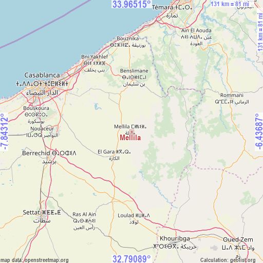
Mellila GPS coordinates[2]
33° 22' 48" North, 7° 8' 24" West
| Map corner | latitude | longitude |
|---|---|---|
| Upper-left | 33.96515°, | -7.84312° |
| Center: | 33.38°, | -7.14° |
| Lower-right: | 32.79089°, | -6.43687° |
| Map W x H: | 130.6×130.6 km | = 81.2×81.2mi |
| max Lat: | 35.84906° ⇑45% North |
| Mellila: | 33.38° |
| min Lat: | ⇓55% South 22.6558° |
| min Long | Mellila | max Long |
| -15.60719° | -7.14° | -1.22855° |
| W 34.1%⇐ | ⇒65.9% E |
Elevation
Elevation of Mellila is 326 m = 1070 ft, and this is 290.8 m = 954 ft below average elevation for this country.
| Max E: |
2637 m = 8652 ft | 60.9% |
| Avg. | 616.8 m = 2024 ft | |
| Mellila | 326 m = 1070 ft | |
Min E: |
1 m = 3 ft | 39.1% |
See also: Morocco elevation on elevation.city.
Geographical zone
Mellila is located in North temperate zone (between Tropic of Cancer and the Arctic Circle). Distance of this Northern Tropic circle is 1105.6 km =687 mi to South.| Distance of | km | miles | from Mellila |
|---|---|---|---|
| North Pole | 6295.6 | 3911.9 | to North |
| Arctic Circle | 3689.7 | 2292.7 | to North |
| Tropic Cancer | 1105.6 | 687 | to South |
| Equator | 3711.5 | 2306.2 | to South |


Nearby cities:
15 places around Mellila: (largest is in red/bold)
• Berrechid
43.5 km =27 mi,  252°
252°
• Boujniba
63.2 km =39.3 mi,  147°
147°
• Bouskoura
48.2 km =30 mi,  279°
279°
• Bouznika
45.6 km =28.3 mi,  357°
357°
• Casablanca
49.5 km =30.8 mi,  297°
297°
• Dar Bouazza
64.6 km =40.1 mi, 283°
• Ezzhiliga
57.4 km =35.7 mi,  98°
98°
• Khouribga
59.6 km =37 mi,  158°
158°
• Mediouna
36.2 km =22.5 mi, 282°
• Mohammedia
40.8 km =25.4 mi,  326°
326°
• Riah
33.5 km =20.8 mi,  220°
220°
• Settat
61.2 km =38 mi,  226°
226°
• Skhirate
53.5 km =33.2 mi,  10°
10°
• Tit Mellil
37.7 km =23.4 mi, 301°
• Zawyat an Nwaçer
44.5 km =27.7 mi,  269°
269°
Sources, notices
• [Note1] Compared only with cities in Morocco existing in our database
• [Src1] Map data: © OpenStreetMap contributors (CC-BY-SA)
• [Src2] Other city data from geonames.org with taken over terms of usage.
• [Src3] Geographical zone / Annual Mean Temperature by Robert A. Rohde @ Wikipedia
