Mohammedia geodata
Mohammedia (Casablanca-Settat) is a seat of a third-order administrative division; located in Morocco in Africa/Casablanca (GMT+1) time zone. With population of 187,708 people, there are 14 cities with bigger population in this country. Compared to other cities in Morocco, 59.3% of cities are located further ↓South; 69% of cities are located further →East and 89.1% of cities have higher elevation than Mohammedia. Note1


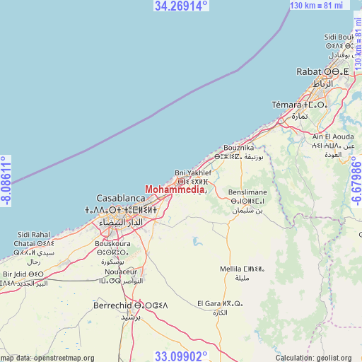
Mohammedia GPS coordinates[2]
33° 41' 9.852" North, 7° 22' 58.728" West
| Map corner | latitude | longitude |
|---|---|---|
| Upper-left | 34.26914°, | -8.08611° |
| Center: | 33.68607°, | -7.38298° |
| Lower-right: | 33.09902°, | -6.67986° |
| Map W x H: | 130.1×130.1 km | = 80.8×80.8mi |
| max Lat: | 35.84906° ⇑40.7% North |
| Mohammedia: | 33.68607° |
| min Lat: | ⇓59.3% South 22.6558° |
| min Long | Mohammedia | max Long |
| -15.60719° | -7.38298° | -1.22855° |
| W 31%⇐ | ⇒69% E |
Elevation
Elevation of Mohammedia is 29 m = 95 ft, and this is 587.8 m = 1928 ft below average elevation for this country.
| Max E: |
2637 m = 8652 ft | 89.1% |
| Avg. | 616.8 m = 2024 ft | |
| Mohammedia | 29 m = 95 ft | |
Min E: |
1 m = 3 ft | 10.9% |
See also: Mohammedia elevation on elevation.city.
Geographical zone
Mohammedia is located in North temperate zone (between Tropic of Cancer and the Arctic Circle). Distance of this Northern Tropic circle is 1139.6 km =708.1 mi to South.| Distance of | km | miles | from Mohammedia |
|---|---|---|---|
| North Pole | 6261.5 | 3890.7 | to North |
| Arctic Circle | 3655.6 | 2271.5 | to North |
| Tropic Cancer | 1139.6 | 708.1 | to South |
| Equator | 3745.5 | 2327.3 | to South |


Nearby cities:
15 places around Mohammedia: (largest is in red/bold)
• Berrechid
50.5 km =31.4 mi,  202°
202°
• Bouskoura
36.2 km =22.5 mi,  223°
223°
• Bouznika
23.6 km =14.7 mi,  60°
60°
• Casablanca
23.8 km =14.8 mi,  242°
242°
• Dar Bouazza
44.4 km =27.6 mi, 244°
• Mediouna
29 km =18 mi,  205°
205°
• Mellila
40.8 km =25.4 mi,  146°
146°
• Rabat
62.5 km =38.8 mi,  54°
54°
• Riah
59.5 km =37 mi,  179°
179°
• Sale
67.7 km =42.1 mi, 52°
• Settat
79.2 km =49.2 mi, 195°
• Skhirate
37.4 km =23.2 mi, 60°
• Temara
51.6 km =32.1 mi, 58°
• Tit Mellil
17.2 km =10.7 mi, 213°
• Zawyat an Nwaçer
40.5 km =25.2 mi, 212°
In other languages:
- In France: Mohammédia
- In German: Fedala
- In Russian: Мохаммедия
- In Chinese: 穆罕默迪耶
Sources, notices
• [Note1] Compared only with cities in Morocco existing in our database
• [Src1] Map data: © OpenStreetMap contributors (CC-BY-SA)
• [Src2] Other city data from geonames.org with taken over terms of usage.
• [Src3] Geographical zone / Annual Mean Temperature by Robert A. Rohde @ Wikipedia
