Tit Mellil geodata
Tit Mellil (Casablanca-Settat) is a seat of a third-order administrative division; located in Morocco in Africa/Casablanca (GMT+1) time zone. In our database, there are 108 cities with bigger population. Compared to other cities in Morocco, 57.8% of cities are located further ↓South; 70.2% of cities are located further →East and 79.5% of cities have higher elevation than Tit Mellil. Note1


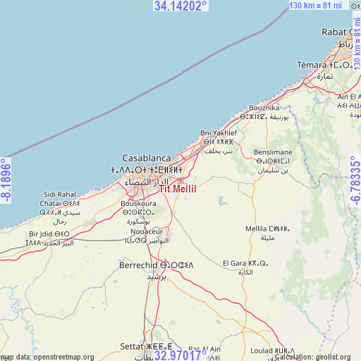
Tit Mellil GPS coordinates[2]
33° 33' 29.088" North, 7° 29' 11.292" West
| Map corner | latitude | longitude |
|---|---|---|
| Upper-left | 34.14202°, | -8.1896° |
| Center: | 33.55808°, | -7.48647° |
| Lower-right: | 32.97017°, | -6.78335° |
| Map W x H: | 130.3×130.3 km | = 81×81mi |
| max Lat: | 35.84906° ⇑42.2% North |
| Tit Mellil: | 33.55808° |
| min Lat: | ⇓57.8% South 22.6558° |
| min Long | Tit Mellil | max Long |
| -15.60719° | -7.48647° | -1.22855° |
| W 29.8%⇐ | ⇒70.2% E |
Elevation
Elevation of Tit Mellil is 119 m = 390 ft, and this is 497.8 m = 1633 ft below average elevation for this country.
| Max E: |
2637 m = 8652 ft | 79.5% |
| Avg. | 616.8 m = 2024 ft | |
| Tit Mellil | 119 m = 390 ft | |
Min E: |
1 m = 3 ft | 20.5% |
See also: Morocco elevation on elevation.city.
Geographical zone
Tit Mellil is located in North temperate zone (between Tropic of Cancer and the Arctic Circle). Distance of this Northern Tropic circle is 1125.4 km =699.3 mi to South.| Distance of | km | miles | from Tit Mellil |
|---|---|---|---|
| North Pole | 6275.8 | 3899.6 | to North |
| Arctic Circle | 3669.9 | 2280.4 | to North |
| Tropic Cancer | 1125.4 | 699.3 | to South |
| Equator | 3731.3 | 2318.5 | to South |


Nearby cities:
15 places around Tit Mellil: (largest is in red/bold)
• Berrechid
33.9 km =21.1 mi,  196°
196°
• Bouskoura
19.5 km =12.1 mi,  231°
231°
• Bouznika
39.7 km =24.7 mi,  49°
49°
• Casablanca
12.1 km =7.5 mi,  286°
286°
• Dar Bouazza
31 km =19.3 mi,  261°
261°
• Mediouna
12.2 km =7.6 mi,  194°
194°
• Mellila
37.7 km =23.4 mi,  121°
121°
• Mohammedia
17.2 km =10.7 mi,  33°
33°
• Rabat
78.8 km =49 mi, 50°
• Riah
46.4 km =28.8 mi,  167°
167°
• Sale
84.1 km =52.3 mi, 49°
• Settat
63.1 km =39.2 mi, 191°
• Skhirate
53.3 km =33.1 mi, 52°
• Temara
67.6 km =42 mi, 52°
• Zawyat an Nwaçer
23.3 km =14.5 mi,  211°
211°
Sources, notices
• [Note1] Compared only with cities in Morocco existing in our database
• [Src1] Map data: © OpenStreetMap contributors (CC-BY-SA)
• [Src2] Other city data from geonames.org with taken over terms of usage.
• [Src3] Geographical zone / Annual Mean Temperature by Robert A. Rohde @ Wikipedia
