Zoumi geodata
Zoumi (Tanger-Tetouan-Al Hoceima) is a seat of a third-order administrative division; located in Morocco in Africa/Casablanca (GMT+1) time zone. In our database, there are 108 cities with bigger population. Compared to other cities in Morocco, 81.8% of cities are located further ↓South; 62% of cities are located further ←West and 56.6% of cities have higher elevation than Zoumi. Note1
Administrative division(s):
- Level 1: Tanger-Tetouan-Al Hoceima
- Level 2: Chefchaouen Province
- Level 3: Zoumi


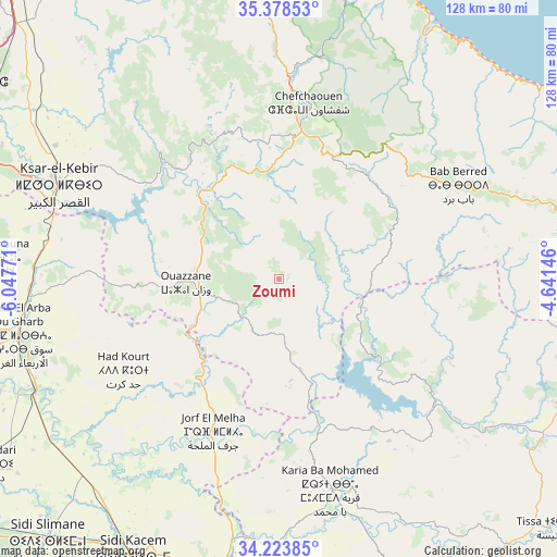
Zoumi GPS coordinates[2]
34° 48' 11.556" North, 5° 20' 40.488" West
| Map corner | latitude | longitude |
|---|---|---|
| Upper-left | 35.37853°, | -6.04771° |
| Center: | 34.80321°, | -5.34458° |
| Lower-right: | 34.22385°, | -4.64146° |
| Map W x H: | 128.4×128.4 km | = 79.8×79.8mi |
| max Lat: | 35.84906° ⇑18.2% North |
| Zoumi: | 34.80321° |
| min Lat: | ⇓81.8% South 22.6558° |
| min Long | Zoumi | max Long |
| -15.60719° | -5.34458° | -1.22855° |
| W 62%⇐ | ⇒38% E |
Elevation
Elevation of Zoumi is 369 m = 1211 ft, and this is 247.8 m = 813 ft below average elevation for this country.
| Max E: |
2637 m = 8652 ft | 56.6% |
| Avg. | 616.8 m = 2024 ft | |
| Zoumi | 369 m = 1211 ft | |
Min E: |
1 m = 3 ft | 43.4% |
See also: Morocco elevation on elevation.city.
Geographical zone
Zoumi is located in North temperate zone (between Tropic of Cancer and the Arctic Circle). Distance of this Northern Tropic circle is 1263.8 km =785.3 mi to South.| Distance of | km | miles | from Zoumi |
|---|---|---|---|
| North Pole | 6137.3 | 3813.5 | to North |
| Arctic Circle | 3531.4 | 2194.3 | to North |
| Tropic Cancer | 1263.8 | 785.3 | to South |
| Equator | 3869.8 | 2404.6 | to South |


Nearby cities:
15 places around Zoumi: (largest is in red/bold)
• Bab Taza
31.7 km =19.7 mi,  24°
24°
• Brikcha
27.7 km =17.2 mi,  311°
311°
• Chefchaouene
41.3 km =25.7 mi,  10°
10°
• Derdara
34.5 km =21.4 mi, 8°
• Fifi
18.4 km =11.4 mi,  28°
28°
• Ghouazi
36.4 km =22.6 mi,  173°
173°
• Had Kourt
41.7 km =25.9 mi,  240°
240°
• Mahroun
28.6 km =17.8 mi, 20°
• Moulay Bouchta
40 km =24.9 mi,  150°
150°
• Ouezzane
21.4 km =13.3 mi,  267°
267°
• Ratba
37.1 km =23.1 mi,  94°
94°
• Sidi Bousber
26.8 km =16.7 mi,  183°
183°
• Sidi Redouane
15.9 km =9.9 mi,  215°
215°
• Tabouda
20.9 km =13 mi,  116°
116°
• Teroual
15.7 km =9.8 mi,  155°
155°
Sources, notices
• [Note1] Compared only with cities in Morocco existing in our database
• [Src1] Map data: © OpenStreetMap contributors (CC-BY-SA)
• [Src2] Other city data from geonames.org with taken over terms of usage.
• [Src3] Geographical zone / Annual Mean Temperature by Robert A. Rohde @ Wikipedia
