Teroual geodata
Teroual (Rabat-Salé-Kénitra) is a seat of a third-order administrative division; located in Morocco in Africa/Casablanca (GMT+1) time zone. In our database, there are 108 cities with bigger population. Compared to other cities in Morocco, 78.3% of cities are located further ↓South; 65.1% of cities are located further ←West and 52.3% of cities have higher elevation than Teroual. Note1


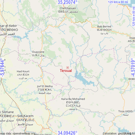
Teroual GPS coordinates[2]
34° 40' 28.272" North, 5° 16' 23.916" West
| Map corner | latitude | longitude |
|---|---|---|
| Upper-left | 35.25074°, | -5.97644° |
| Center: | 34.67452°, | -5.27331° |
| Lower-right: | 34.09426°, | -4.57019° |
| Map W x H: | 128.6×128.6 km | = 79.9×79.9mi |
| max Lat: | 35.84906° ⇑21.7% North |
| Teroual: | 34.67452° |
| min Lat: | ⇓78.3% South 22.6558° |
| min Long | Teroual | max Long |
| -15.60719° | -5.27331° | -1.22855° |
| W 65.1%⇐ | ⇒34.9% E |
Elevation
Elevation of Teroual is 426 m = 1398 ft, and this is 190.8 m = 626 ft below average elevation for this country.
| Max E: |
2637 m = 8652 ft | 52.3% |
| Avg. | 616.8 m = 2024 ft | |
| Teroual | 426 m = 1398 ft | |
Min E: |
1 m = 3 ft | 47.7% |
See also: Morocco elevation on elevation.city.
Geographical zone
Teroual is located in North temperate zone (between Tropic of Cancer and the Arctic Circle). Distance of this Northern Tropic circle is 1249.5 km =776.4 mi to South.| Distance of | km | miles | from Teroual |
|---|---|---|---|
| North Pole | 6151.6 | 3822.4 | to North |
| Arctic Circle | 3545.7 | 2203.2 | to North |
| Tropic Cancer | 1249.5 | 776.4 | to South |
| Equator | 3855.4 | 2395.6 | to South |


Nearby cities:
15 places around Teroual: (largest is in red/bold)
• Bab Taza
43.6 km =27.1 mi,  9°
9°
• Brikcha
42.5 km =26.4 mi,  319°
319°
• Fifi
30.6 km =19 mi,  4°
4°
• Ghouazi
22.1 km =13.7 mi,  186°
186°
• Had Kourt
43.2 km =26.8 mi,  261°
261°
• Karia Ba Mohamed
34.2 km =21.3 mi,  170°
170°
• Mahroun
41.2 km =25.6 mi, 5°
• Moulay Bouchta
24.4 km =15.2 mi,  147°
147°
• Ouezzane
31 km =19.3 mi,  295°
295°
• Ourtzagh
31.9 km =19.8 mi,  119°
119°
• Ratba
32.6 km =20.3 mi,  69°
69°
• Sidi Bousber
14.8 km =9.2 mi,  213°
213°
• Sidi Redouane
15.8 km =9.8 mi,  275°
275°
• Tabouda
13.1 km =8.1 mi, 67°
• Zoumi
15.7 km =9.8 mi,  335°
335°
Sources, notices
• [Note1] Compared only with cities in Morocco existing in our database
• [Src1] Map data: © OpenStreetMap contributors (CC-BY-SA)
• [Src2] Other city data from geonames.org with taken over terms of usage.
• [Src3] Geographical zone / Annual Mean Temperature by Robert A. Rohde @ Wikipedia
