Ghouazi geodata
Ghouazi (Fès-Meknès) is a seat of a third-order administrative division; located in Morocco in Africa/Casablanca (GMT+1) time zone. In our database, there are 108 cities with bigger population. Compared to other cities in Morocco, 73.6% of cities are located further ↓South; 63.6% of cities are located further ←West and 82.2% of cities have higher elevation than Ghouazi. Note1


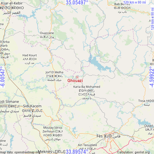
Ghouazi GPS coordinates[2]
34° 28' 38.532" North, 5° 18' 8.46" West
| Map corner | latitude | longitude |
|---|---|---|
| Upper-left | 35.05497°, | -6.00547° |
| Center: | 34.47737°, | -5.30235° |
| Lower-right: | 33.89574°, | -4.59922° |
| Map W x H: | 128.9×128.9 km | = 80.1×80.1mi |
| max Lat: | 35.84906° ⇑26.4% North |
| Ghouazi: | 34.47737° |
| min Lat: | ⇓73.6% South 22.6558° |
| min Long | Ghouazi | max Long |
| -15.60719° | -5.30235° | -1.22855° |
| W 63.6%⇐ | ⇒36.4% E |
Elevation
Elevation of Ghouazi is 77 m = 253 ft, and this is 539.8 m = 1771 ft below average elevation for this country.
| Max E: |
2637 m = 8652 ft | 82.2% |
| Avg. | 616.8 m = 2024 ft | |
| Ghouazi | 77 m = 253 ft | |
Min E: |
1 m = 3 ft | 17.8% |
See also: Morocco elevation on elevation.city.
Geographical zone
Ghouazi is located in North temperate zone (between Tropic of Cancer and the Arctic Circle). Distance of this Northern Tropic circle is 1227.6 km =762.8 mi to South.| Distance of | km | miles | from Ghouazi |
|---|---|---|---|
| North Pole | 6173.5 | 3836 | to North |
| Arctic Circle | 3567.6 | 2216.8 | to North |
| Tropic Cancer | 1227.6 | 762.8 | to South |
| Equator | 3833.5 | 2382 | to South |


Nearby cities:
15 places around Ghouazi: (largest is in red/bold)
• Bouarouss
47 km =29.2 mi,  106°
106°
• Galaz
46.3 km =28.8 mi,  80°
80°
• Had Kourt
43 km =26.7 mi,  291°
291°
• Karia Ba Mohamed
14.4 km =8.9 mi,  145°
145°
• Moulay Bouchta
15.8 km =9.8 mi,  85°
85°
• Moulay Yacoub
44.7 km =27.8 mi,  165°
165°
• Ouezzane
43.5 km =27 mi,  324°
324°
• Ourtzagh
31.2 km =19.4 mi, 78°
• Ratba
47.1 km =29.3 mi,  44°
44°
• Sidi Bousber
11 km =6.8 mi,  330°
330°
• Sidi Qacem
46.8 km =29.1 mi,  232°
232°
• Sidi Redouane
26.7 km =16.6 mi, 330°
• Tabouda
30.7 km =19.1 mi,  28°
28°
• Teroual
22.1 km =13.7 mi,  6°
6°
• Zoumi
36.4 km =22.6 mi,  353°
353°
Sources, notices
• [Note1] Compared only with cities in Morocco existing in our database
• [Src1] Map data: © OpenStreetMap contributors (CC-BY-SA)
• [Src2] Other city data from geonames.org with taken over terms of usage.
• [Src3] Geographical zone / Annual Mean Temperature by Robert A. Rohde @ Wikipedia
