El Ksiba geodata
El Ksiba (Béni Mellal-Khénifra) is a seat of a third-order administrative division; located in Morocco in Africa/Casablanca (GMT+1) time zone. In our database, there are 108 cities with bigger population. Compared to other cities in Morocco, 58.1% of cities are located further ↑North; 51.2% of cities are located further →East and 80.6% of cities have lower elevation than El Ksiba. Note1


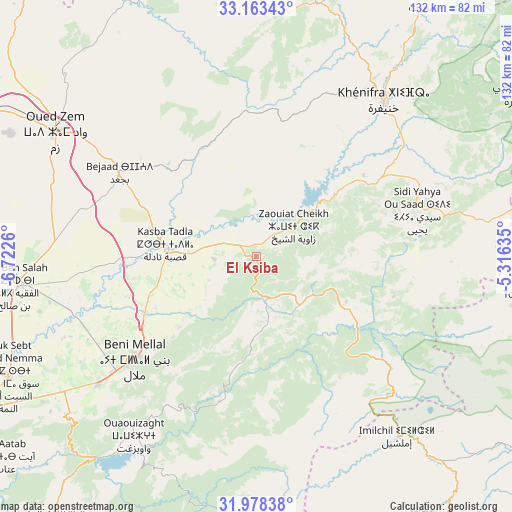
El Ksiba GPS coordinates[2]
32° 34' 22.296" North, 6° 1' 10.092" West
| Map corner | latitude | longitude |
|---|---|---|
| Upper-left | 33.16343°, | -6.7226° |
| Center: | 32.57286°, | -6.01947° |
| Lower-right: | 31.97838°, | -5.31635° |
| Map W x H: | 131.8×131.8 km | = 81.9×81.9mi |
| max Lat: | 35.84906° ⇑58.1% North |
| El Ksiba: | 32.57286° |
| min Lat: | ⇓41.9% South 22.6558° |
| min Long | El Ksiba | max Long |
| -15.60719° | -6.01947° | -1.22855° |
| W 48.8%⇐ | ⇒51.2% E |
Elevation
Elevation of El Ksiba is 1079 m = 3540 ft, and this is 462.2 m = 1516 ft above average elevation for this country.
| Max E: |
2637 m = 8652 ft | 19.4% |
| El Ksiba | 1079 m 3540 ft | |
| Avg. | 616.8 m = 2024 ft | |
Min E: |
1 m = 3 ft | 80.6% |
See also: Morocco elevation on elevation.city.
Geographical zone
El Ksiba is located in North temperate zone (between Tropic of Cancer and the Arctic Circle). Distance of this Northern Tropic circle is 1015.8 km =631.2 mi to South.| Distance of | km | miles | from El Ksiba |
|---|---|---|---|
| North Pole | 6385.3 | 3967.6 | to North |
| Arctic Circle | 3779.4 | 2348.4 | to North |
| Tropic Cancer | 1015.8 | 631.2 | to South |
| Equator | 3621.8 | 2250.5 | to South |


Nearby cities:
15 places around El Ksiba: (largest is in red/bold)
• Aguelmous
67.4 km =41.9 mi,  13°
13°
• Al Fqih Ben Çalah
63.1 km =39.2 mi,  262°
262°
• Anergui
56.5 km =35.1 mi,  172°
172°
• Beni Mellal
40.6 km =25.2 mi,  229°
229°
• Imilchil
59.6 km =37 mi,  141°
141°
• Isseksi
45.1 km =28 mi,  212°
212°
• Kasba Tadla
23.5 km =14.6 mi,  276°
276°
• Khenifra
52.3 km =32.5 mi,  39°
39°
• Oued Zem
61 km =37.9 mi,  301°
301°
• Sidi Amar
45.4 km =28.2 mi,  22°
22°
• Sidi Jaber
42.8 km =26.6 mi,  241°
241°
• Sidi Lamine
37.4 km =23.2 mi,  355°
355°
• Sidi Yahya Ou Saad
43.1 km =26.8 mi,  73°
73°
• Timoulilt
58.7 km =36.5 mi, 225°
• Zawyat ech Cheïkh
12.4 km =7.7 mi,  49°
49°
Sources, notices
• [Note1] Compared only with cities in Morocco existing in our database
• [Src1] Map data: © OpenStreetMap contributors (CC-BY-SA)
• [Src2] Other city data from geonames.org with taken over terms of usage.
• [Src3] Geographical zone / Annual Mean Temperature by Robert A. Rohde @ Wikipedia
