Galaz geodata
Galaz (Fès-Meknès) is a seat of a third-order administrative division; located in Morocco in Africa/Casablanca (GMT+1) time zone. In our database, there are 108 cities with bigger population. Compared to other cities in Morocco, 75.6% of cities are located further ↓South; 76.7% of cities are located further ←West and 67.8% of cities have higher elevation than Galaz. Note1


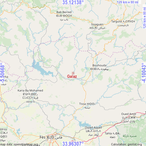
Galaz GPS coordinates[2]
34° 32' 39.264" North, 4° 48' 12.78" West
| Map corner | latitude | longitude |
|---|---|---|
| Upper-left | 35.12138°, | -5.50668° |
| Center: | 34.54424°, | -4.80355° |
| Lower-right: | 33.96307°, | -4.10043° |
| Map W x H: | 128.8×128.8 km | = 80×80mi |
| max Lat: | 35.84906° ⇑24.4% North |
| Galaz: | 34.54424° |
| min Lat: | ⇓75.6% South 22.6558° |
| min Long | Galaz | max Long |
| -15.60719° | -4.80355° | -1.22855° |
| W 76.7%⇐ | ⇒23.3% E |
Elevation
Elevation of Galaz is 243 m = 797 ft, and this is 373.8 m = 1226 ft below average elevation for this country.
| Max E: |
2637 m = 8652 ft | 67.8% |
| Avg. | 616.8 m = 2024 ft | |
| Galaz | 243 m = 797 ft | |
Min E: |
1 m = 3 ft | 32.2% |
See also: Morocco elevation on elevation.city.
Geographical zone
Galaz is located in North temperate zone (between Tropic of Cancer and the Arctic Circle). Distance of this Northern Tropic circle is 1235 km =767.4 mi to South.| Distance of | km | miles | from Galaz |
|---|---|---|---|
| North Pole | 6166.1 | 3831.4 | to North |
| Arctic Circle | 3560.2 | 2212.2 | to North |
| Tropic Cancer | 1235 | 767.4 | to South |
| Equator | 3841 | 2386.7 | to South |


Nearby cities:
15 places around Galaz: (largest is in red/bold)
• Bouarouss
20.5 km =12.7 mi,  181°
181°
• Fès al Bali
54.5 km =33.9 mi,  194°
194°
• Ghouazi
46.3 km =28.8 mi,  260°
260°
• Karia Ba Mohamed
42.3 km =26.3 mi,  242°
242°
• Moulay Bouchta
30.5 km =19 mi, 258°
• Oulad Daoud
18.5 km =11.5 mi,  147°
147°
• Ourtzagh
15.2 km =9.4 mi,  266°
266°
• Ratba
28.8 km =17.9 mi,  334°
334°
• Sidi Bousber
51.2 km =31.8 mi, 272°
• Tabouda
36.4 km =22.6 mi,  302°
302°
• Tamorot
43.7 km =27.2 mi,  2°
2°
• Taounate
15 km =9.3 mi,  93°
93°
• Teroual
45.4 km =28.2 mi,  288°
288°
• Timezgana
7.8 km =4.8 mi,  59°
59°
• Tissa
31.3 km =19.4 mi,  155°
155°
Sources, notices
• [Note1] Compared only with cities in Morocco existing in our database
• [Src1] Map data: © OpenStreetMap contributors (CC-BY-SA)
• [Src2] Other city data from geonames.org with taken over terms of usage.
• [Src3] Geographical zone / Annual Mean Temperature by Robert A. Rohde @ Wikipedia
