Tamorot geodata
Tamorot (Tanger-Tetouan-Al Hoceima) is a seat of a third-order administrative division; located in Morocco in Africa/Casablanca (GMT+1) time zone. In our database, there are 108 cities with bigger population. Compared to other cities in Morocco, 84.1% of cities are located further ↓South; 77.1% of cities are located further ←West and 73.6% of cities have lower elevation than Tamorot. Note1
Administrative division(s):
- Level 1: Tanger-Tetouan-Al Hoceima
- Level 2: Chefchaouen Province
- Level 3: Tamorot


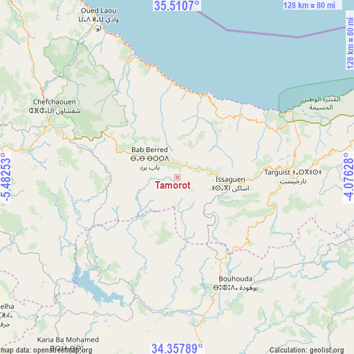
Tamorot GPS coordinates[2]
34° 56' 10.752" North, 4° 46' 45.84" West
| Map corner | latitude | longitude |
|---|---|---|
| Upper-left | 35.5107°, | -5.48253° |
| Center: | 34.93632°, | -4.7794° |
| Lower-right: | 34.35789°, | -4.07628° |
| Map W x H: | 128.2×128.2 km | = 79.7×79.7mi |
| max Lat: | 35.84906° ⇑15.9% North |
| Tamorot: | 34.93632° |
| min Lat: | ⇓84.1% South 22.6558° |
| min Long | Tamorot | max Long |
| -15.60719° | -4.7794° | -1.22855° |
| W 77.1%⇐ | ⇒22.9% E |
Elevation
Elevation of Tamorot is 979 m = 3212 ft, and this is 362.2 m = 1188 ft above average elevation for this country.
| Max E: |
2637 m = 8652 ft | 26.4% |
| Tamorot | 979 m 3212 ft | |
| Avg. | 616.8 m = 2024 ft | |
Min E: |
1 m = 3 ft | 73.6% |
See also: Morocco elevation on elevation.city.
Geographical zone
Tamorot is located in North temperate zone (between Tropic of Cancer and the Arctic Circle). Distance of this Northern Tropic circle is 1278.6 km =794.5 mi to South.| Distance of | km | miles | from Tamorot |
|---|---|---|---|
| North Pole | 6122.5 | 3804.3 | to North |
| Arctic Circle | 3516.6 | 2185.1 | to North |
| Tropic Cancer | 1278.6 | 794.5 | to South |
| Equator | 3884.6 | 2413.8 | to South |


Nearby cities:
15 places around Tamorot: (largest is in red/bold)
• Bab Taza
40.6 km =25.2 mi,  290°
290°
• Chefchaouene
51.1 km =31.8 mi,  300°
300°
• Derdara
50.4 km =31.3 mi, 292°
• Fifi
42.7 km =26.5 mi,  271°
271°
• Galaz
43.7 km =27.2 mi,  182°
182°
• Mahroun
43.1 km =26.8 mi, 286°
• Ourtzagh
47.9 km =29.8 mi,  201°
201°
• Ratba
22.9 km =14.2 mi,  219°
219°
• Senada
53.6 km =33.3 mi,  73°
73°
• Tabouda
40.8 km =25.4 mi,  233°
233°
• Taounate
46.2 km =28.7 mi,  164°
164°
• Targuist
42 km =26.1 mi,  89°
89°
• Teroual
53.7 km =33.4 mi,  237°
237°
• Timezgana
39.9 km =24.8 mi,  173°
173°
• Zoumi
53.6 km =33.3 mi,  253°
253°
Sources, notices
• [Note1] Compared only with cities in Morocco existing in our database
• [Src1] Map data: © OpenStreetMap contributors (CC-BY-SA)
• [Src2] Other city data from geonames.org with taken over terms of usage.
• [Src3] Geographical zone / Annual Mean Temperature by Robert A. Rohde @ Wikipedia
