Fès al Bali geodata
Fès al Bali (Fès-Meknès) is a section of populated place; located in Morocco in Africa/Casablanca (GMT+1) time zone. With population of 156,000 people, there are 17 cities with bigger population in this country. Compared to other cities in Morocco, 67.1% of cities are located further ↓South; 73.6% of cities are located further ←West and 69.4% of cities have higher elevation than Fès al Bali. Note1


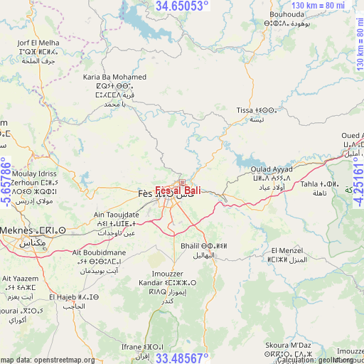
Fès al Bali GPS coordinates[2]
34° 4' 12.36" North, 4° 57' 17.028" West
| Map corner | latitude | longitude |
|---|---|---|
| Upper-left | 34.65053°, | -5.65786° |
| Center: | 34.0701°, | -4.95473° |
| Lower-right: | 33.48567°, | -4.25161° |
| Map W x H: | 129.5×129.5 km | = 80.5×80.5mi |
| max Lat: | 35.84906° ⇑32.9% North |
| Fès al Bali: | 34.0701° |
| min Lat: | ⇓67.1% South 22.6558° |
| min Long | Fès al Bali | max Long |
| -15.60719° | -4.95473° | -1.22855° |
| W 73.6%⇐ | ⇒26.4% E |
Elevation
Elevation of Fès al Bali is 237 m = 778 ft, and this is 379.8 m = 1246 ft below average elevation for this country.
| Max E: |
2637 m = 8652 ft | 69.4% |
| Avg. | 616.8 m = 2024 ft | |
| Fès al Bali | 237 m = 778 ft | |
Min E: |
1 m = 3 ft | 30.6% |
See also: Fès al Bali elevation on elevation.city.
Geographical zone
Fès al Bali is located in North temperate zone (between Tropic of Cancer and the Arctic Circle). Distance of this Northern Tropic circle is 1182.3 km =734.6 mi to South.| Distance of | km | miles | from Fès al Bali |
|---|---|---|---|
| North Pole | 6218.8 | 3864.2 | to North |
| Arctic Circle | 3612.9 | 2245 | to North |
| Tropic Cancer | 1182.3 | 734.6 | to South |
| Equator | 3788.2 | 2353.9 | to South |


Nearby cities:
15 places around Fès al Bali: (largest is in red/bold)
• Bhalil
25.4 km =15.8 mi,  162°
162°
• Bouarouss
34.9 km =21.7 mi,  22°
22°
• Fès
5.9 km =3.7 mi,  225°
225°
• Karia Ba Mohamed
41.1 km =25.5 mi,  324°
324°
• Matmata
37.2 km =23.1 mi,  85°
85°
• Moulay Bouchta
49.3 km =30.6 mi,  340°
340°
• Moulay Yacoub
21 km =13 mi,  275°
275°
• Oulad Daoud
44.3 km =27.5 mi,  32°
32°
• Oulad Tayeb
14.3 km =8.9 mi,  195°
195°
• Ourtzagh
51.7 km =32.1 mi,  358°
358°
• Sefrou
29 km =18 mi, 156°
• Sidi Harazem
8.1 km =5 mi,  125°
125°
• Tahla
49.2 km =30.6 mi, 92°
• Tazouta
53.5 km =33.2 mi,  146°
146°
• Tissa
36.1 km =22.4 mi,  47°
47°
Sources, notices
• [Note1] Compared only with cities in Morocco existing in our database
• [Src1] Map data: © OpenStreetMap contributors (CC-BY-SA)
• [Src2] Other city data from geonames.org with taken over terms of usage.
• [Src3] Geographical zone / Annual Mean Temperature by Robert A. Rohde @ Wikipedia
