Boujniba geodata
Boujniba (Béni Mellal-Khénifra) is a populated place; located in Morocco in Africa/Casablanca (GMT+1) time zone. With population of 15,041 people, there are 83 cities with bigger population in this country. Compared to other cities in Morocco, 51.9% of cities are located further ↑North; 60.9% of cities are located further →East and 66.7% of cities have lower elevation than Boujniba. Note1


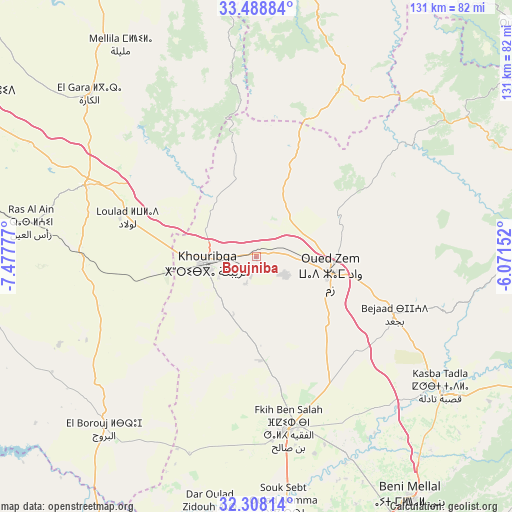
Boujniba GPS coordinates[2]
32° 54' 1.656" North, 6° 46' 28.704" West
| Map corner | latitude | longitude |
|---|---|---|
| Upper-left | 33.48884°, | -7.47777° |
| Center: | 32.90046°, | -6.77464° |
| Lower-right: | 32.30814°, | -6.07152° |
| Map W x H: | 131.3×131.3 km | = 81.6×81.6mi |
| max Lat: | 35.84906° ⇑51.9% North |
| Boujniba: | 32.90046° |
| min Lat: | ⇓48.1% South 22.6558° |
| min Long | Boujniba | max Long |
| -15.60719° | -6.77464° | -1.22855° |
| W 39.1%⇐ | ⇒60.9% E |
Elevation
Elevation of Boujniba is 847 m = 2779 ft, and this is 230.2 m = 755 ft above average elevation for this country.
| Max E: |
2637 m = 8652 ft | 33.3% |
| Boujniba | 847 m 2779 ft | |
| Avg. | 616.8 m = 2024 ft | |
Min E: |
1 m = 3 ft | 66.7% |
See also: Morocco elevation on elevation.city.
Geographical zone
Boujniba is located in North temperate zone (between Tropic of Cancer and the Arctic Circle). Distance of this Northern Tropic circle is 1052.3 km =653.9 mi to South.| Distance of | km | miles | from Boujniba |
|---|---|---|---|
| North Pole | 6348.9 | 3945 | to North |
| Arctic Circle | 3743 | 2325.8 | to North |
| Tropic Cancer | 1052.3 | 653.9 | to South |
| Equator | 3658.2 | 2273.1 | to South |


Nearby cities:
15 places around Boujniba: (largest is in red/bold)
• Al Fqih Ben Çalah
45 km =28 mi,  169°
169°
• Beni Mellal
74.2 km =46.1 mi,  147°
147°
• Dar Ould Zidouh
66.5 km =41.3 mi,  190°
190°
• El Ksiba
79.5 km =49.4 mi,  117°
117°
• Ezzhiliga
49.9 km =31 mi,  27°
27°
• Guisser
69.2 km =43 mi,  257°
257°
• Kasba Tadla
58.1 km =36.1 mi,  125°
125°
• Khouribga
12.5 km =7.8 mi, 260°
• Mellila
63.2 km =39.3 mi,  327°
327°
• Oued Zem
19.2 km =11.9 mi,  102°
102°
• Oulad Ayad
77.9 km =48.4 mi,  181°
181°
• Riah
62.5 km =38.8 mi,  296°
296°
• Settat
79.4 km =49.3 mi,  278°
278°
• Sidi Jaber
65.8 km =40.9 mi, 149°
• Sidi Lamine
67.6 km =42 mi,  89°
89°
Sources, notices
• [Note1] Compared only with cities in Morocco existing in our database
• [Src1] Map data: © OpenStreetMap contributors (CC-BY-SA)
• [Src2] Other city data from geonames.org with taken over terms of usage.
• [Src3] Geographical zone / Annual Mean Temperature by Robert A. Rohde @ Wikipedia
