Tahla geodata
Tahla (Fès-Meknès) is a seat of a third-order administrative division; located in Morocco in Africa/Casablanca (GMT+1) time zone. With population of 25,761 people, there are 74 cities with bigger population in this country. Compared to other cities in Morocco, 66.3% of cities are located further ↓South; 81.8% of cities are located further ←West and 58.1% of cities have lower elevation than Tahla. Note1


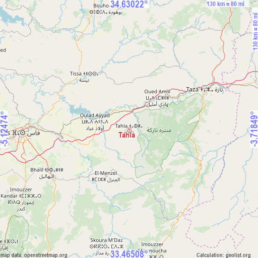
Tahla GPS coordinates[2]
34° 2' 58.74" North, 4° 25' 17.832" West
| Map corner | latitude | longitude |
|---|---|---|
| Upper-left | 34.63022°, | -5.12474° |
| Center: | 34.04965°, | -4.42162° |
| Lower-right: | 33.46508°, | -3.71849° |
| Map W x H: | 129.6×129.6 km | = 80.5×80.5mi |
| max Lat: | 35.84906° ⇑33.7% North |
| Tahla: | 34.04965° |
| min Lat: | ⇓66.3% South 22.6558° |
| min Long | Tahla | max Long |
| -15.60719° | -4.42162° | -1.22855° |
| W 81.8%⇐ | ⇒18.2% E |
Elevation
Elevation of Tahla is 606 m = 1988 ft, and this is 10.8 m = 35 ft below average elevation for this country.
| Max E: |
2637 m = 8652 ft | 41.9% |
| Avg. | 616.8 m = 2024 ft | |
| Tahla | 606 m = 1988 ft | |
Min E: |
1 m = 3 ft | 58.1% |
See also: Morocco elevation on elevation.city.
Geographical zone
Tahla is located in North temperate zone (between Tropic of Cancer and the Arctic Circle). Distance of this Northern Tropic circle is 1180 km =733.2 mi to South.| Distance of | km | miles | from Tahla |
|---|---|---|---|
| North Pole | 6221.1 | 3865.6 | to North |
| Arctic Circle | 3615.2 | 2246.4 | to North |
| Tropic Cancer | 1180 | 733.2 | to South |
| Equator | 3786 | 2352.5 | to South |


Nearby cities:
15 places around Tahla: (largest is in red/bold)
• Bhalil
47 km =29.2 mi,  242°
242°
• Bouarouss
49.7 km =30.9 mi,  314°
314°
• Fès
53.3 km =33.1 mi,  268°
268°
• Fès al Bali
49.2 km =30.6 mi, 272°
• Matmata
13.2 km =8.2 mi,  294°
294°
• Oued Amlil
21.2 km =13.2 mi,  37°
37°
• Oulad Daoud
46.7 km =29 mi,  327°
327°
• Oulad Tayeb
54.1 km =33.6 mi,  257°
257°
• Sefrou
44.6 km =27.7 mi, 237°
• Sidi Harazem
42.6 km =26.5 mi, 266°
• Taza
41.9 km =26 mi,  64°
64°
• Tazarine
28.5 km =17.7 mi,  130°
130°
• Tazouta
46.6 km =29 mi,  204°
204°
• Tissa
34.6 km =21.5 mi,  319°
319°
• Tmourghout
39.7 km =24.7 mi,  113°
113°
Sources, notices
• [Note1] Compared only with cities in Morocco existing in our database
• [Src1] Map data: © OpenStreetMap contributors (CC-BY-SA)
• [Src2] Other city data from geonames.org with taken over terms of usage.
• [Src3] Geographical zone / Annual Mean Temperature by Robert A. Rohde @ Wikipedia
