Tazouta geodata
Tazouta (Fès-Meknès) is a seat of a third-order administrative division; located in Morocco in Africa/Casablanca (GMT+1) time zone. In our database, there are 108 cities with bigger population. Compared to other cities in Morocco, 58.9% of cities are located further ↓South; 79.8% of cities are located further ←West and 82.9% of cities have lower elevation than Tazouta. Note1


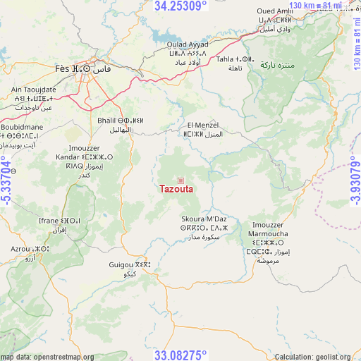
Tazouta GPS coordinates[2]
33° 40' 11.676" North, 4° 38' 2.112" West
| Map corner | latitude | longitude |
|---|---|---|
| Upper-left | 34.25309°, | -5.33704° |
| Center: | 33.66991°, | -4.63392° |
| Lower-right: | 33.08275°, | -3.93079° |
| Map W x H: | 130.1×130.1 km | = 80.8×80.8mi |
| max Lat: | 35.84906° ⇑41.1% North |
| Tazouta: | 33.66991° |
| min Lat: | ⇓58.9% South 22.6558° |
| min Long | Tazouta | max Long |
| -15.60719° | -4.63392° | -1.22855° |
| W 79.8%⇐ | ⇒20.2% E |
Elevation
Elevation of Tazouta is 1146 m = 3760 ft, and this is 529.2 m = 1736 ft above average elevation for this country.
| Max E: |
2637 m = 8652 ft | 17.1% |
| Tazouta | 1146 m 3760 ft | |
| Avg. | 616.8 m = 2024 ft | |
Min E: |
1 m = 3 ft | 82.9% |
See also: Morocco elevation on elevation.city.
Geographical zone
Tazouta is located in North temperate zone (between Tropic of Cancer and the Arctic Circle). Distance of this Northern Tropic circle is 1137.8 km =707 mi to South.| Distance of | km | miles | from Tazouta |
|---|---|---|---|
| North Pole | 6263.3 | 3891.8 | to North |
| Arctic Circle | 3657.4 | 2272.6 | to North |
| Tropic Cancer | 1137.8 | 707 | to South |
| Equator | 3743.7 | 2326.2 | to South |


Nearby cities:
15 places around Tazouta: (largest is in red/bold)
• Almis Marmoucha
57.3 km =35.6 mi,  132°
132°
• Azrou
60.4 km =37.5 mi,  244°
244°
• Bhalil
29.9 km =18.6 mi,  312°
312°
• Boulemane
35.2 km =21.9 mi,  194°
194°
• Fès
52.7 km =32.7 mi,  320°
320°
• Fès al Bali
53.5 km =33.2 mi,  326°
326°
• Ifrane
46.9 km =29.1 mi,  250°
250°
• Matmata
48.3 km =30 mi,  8°
8°
• Oulad Tayeb
45.4 km =28.2 mi, 312°
• Sefrou
25.4 km =15.8 mi, 315°
• Sidi Harazem
45.9 km =28.5 mi, 329°
• Tahla
46.6 km =29 mi,  24°
24°
• Talzemt
42 km =26.1 mi,  102°
102°
• Tazarine
47.7 km =29.6 mi,  60°
60°
• Tmourghout
62 km =38.5 mi, 64°
Sources, notices
• [Note1] Compared only with cities in Morocco existing in our database
• [Src1] Map data: © OpenStreetMap contributors (CC-BY-SA)
• [Src2] Other city data from geonames.org with taken over terms of usage.
• [Src3] Geographical zone / Annual Mean Temperature by Robert A. Rohde @ Wikipedia
