Matmata geodata
Matmata (Fès-Meknès) is a seat of a third-order administrative division; located in Morocco in Africa/Casablanca (GMT+1) time zone. In our database, there are 108 cities with bigger population. Compared to other cities in Morocco, 67.8% of cities are located further ↓South; 80.2% of cities are located further ←West and 63.2% of cities have higher elevation than Matmata. Note1


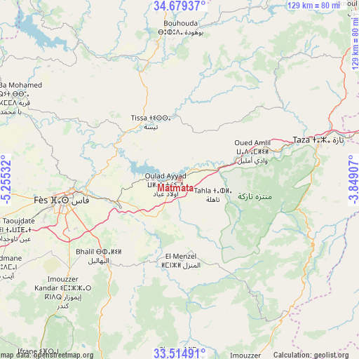
Matmata GPS coordinates[2]
34° 5' 56.904" North, 4° 33' 7.884" West
| Map corner | latitude | longitude |
|---|---|---|
| Upper-left | 34.67937°, | -5.25532° |
| Center: | 34.09914°, | -4.55219° |
| Lower-right: | 33.51491°, | -3.84907° |
| Map W x H: | 129.5×129.5 km | = 80.5×80.5mi |
| max Lat: | 35.84906° ⇑32.2% North |
| Matmata: | 34.09914° |
| min Lat: | ⇓67.8% South 22.6558° |
| min Long | Matmata | max Long |
| -15.60719° | -4.55219° | -1.22855° |
| W 80.2%⇐ | ⇒19.8% E |
Elevation
Elevation of Matmata is 306 m = 1004 ft, and this is 310.8 m = 1020 ft below average elevation for this country.
| Max E: |
2637 m = 8652 ft | 63.2% |
| Avg. | 616.8 m = 2024 ft | |
| Matmata | 306 m = 1004 ft | |
Min E: |
1 m = 3 ft | 36.8% |
See also: Morocco elevation on elevation.city.
Geographical zone
Matmata is located in North temperate zone (between Tropic of Cancer and the Arctic Circle). Distance of this Northern Tropic circle is 1185.5 km =736.6 mi to South.| Distance of | km | miles | from Matmata |
|---|---|---|---|
| North Pole | 6215.6 | 3862.2 | to North |
| Arctic Circle | 3609.7 | 2243 | to North |
| Tropic Cancer | 1185.5 | 736.6 | to South |
| Equator | 3791.5 | 2355.9 | to South |


Nearby cities:
15 places around Matmata: (largest is in red/bold)
• Bhalil
40.3 km =25 mi,  227°
227°
• Bouarouss
37.5 km =23.3 mi,  320°
320°
• Fès
41.9 km =26 mi,  259°
259°
• Fès al Bali
37.2 km =23.1 mi,  265°
265°
• Oued Amlil
27.4 km =17 mi,  65°
65°
• Oulad Daoud
36.3 km =22.6 mi,  339°
339°
• Oulad Tayeb
44.2 km =27.5 mi,  247°
247°
• Sefrou
39.1 km =24.3 mi,  220°
220°
• Sidi Harazem
31.5 km =19.6 mi, 255°
• Tahla
13.2 km =8.2 mi,  114°
114°
• Taounate
49.3 km =30.6 mi,  350°
350°
• Taza
51.4 km =31.9 mi,  76°
76°
• Tazarine
41.4 km =25.7 mi,  125°
125°
• Tazouta
48.3 km =30 mi,  188°
188°
• Tissa
23.4 km =14.5 mi,  333°
333°
Sources, notices
• [Note1] Compared only with cities in Morocco existing in our database
• [Src1] Map data: © OpenStreetMap contributors (CC-BY-SA)
• [Src2] Other city data from geonames.org with taken over terms of usage.
• [Src3] Geographical zone / Annual Mean Temperature by Robert A. Rohde @ Wikipedia
