Fès geodata
Fès (Fès-Meknès) is a seat of a first-order administrative division; located in Morocco in Africa/Casablanca (GMT+1) time zone. With population of 964,891 people, there are 2 cities with bigger population in this country. Compared to other cities in Morocco, 65.9% of cities are located further ↓South; 72.5% of cities are located further ←West and 53.9% of cities have higher elevation than Fès. Note1


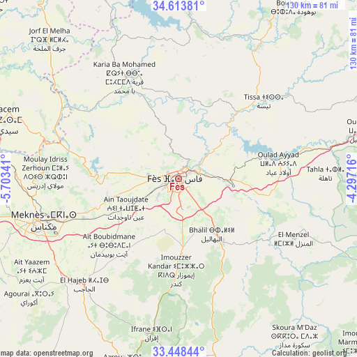
Fès GPS coordinates[2]
34° 1' 59.268" North, 5° 0' 1.008" West
| Map corner | latitude | longitude |
|---|---|---|
| Upper-left | 34.61381°, | -5.70341° |
| Center: | 34.03313°, | -5.00028° |
| Lower-right: | 33.44844°, | -4.29716° |
| Map W x H: | 129.6×129.6 km | = 80.5×80.5mi |
| max Lat: | 35.84906° ⇑34.1% North |
| Fès: | 34.03313° |
| min Lat: | ⇓65.9% South 22.6558° |
| min Long | Fès | max Long |
| -15.60719° | -5.00028° | -1.22855° |
| W 72.5%⇐ | ⇒27.5% E |
Elevation
Elevation of Fès is 406 m = 1332 ft, and this is 210.8 m = 692 ft below average elevation for this country.
| Max E: |
2637 m = 8652 ft | 53.9% |
| Avg. | 616.8 m = 2024 ft | |
| Fès | 406 m = 1332 ft | |
Min E: |
1 m = 3 ft | 46.1% |
See also: Fès elevation on elevation.city.
Geographical zone
Fès is located in North temperate zone (between Tropic of Cancer and the Arctic Circle). Distance of this Northern Tropic circle is 1178.2 km =732.1 mi to South.| Distance of | km | miles | from Fès |
|---|---|---|---|
| North Pole | 6222.9 | 3866.7 | to North |
| Arctic Circle | 3617 | 2247.5 | to North |
| Tropic Cancer | 1178.2 | 732.1 | to South |
| Equator | 3784.1 | 2351.3 | to South |


Nearby cities:
15 places around Fès: (largest is in red/bold)
• Bhalil
23.4 km =14.5 mi,  149°
149°
• Bouarouss
40.3 km =25 mi,  25°
25°
• El Hajeb
51.4 km =31.9 mi,  221°
221°
• Fès al Bali
5.9 km =3.7 mi,  45°
45°
• Karia Ba Mohamed
42.4 km =26.3 mi,  332°
332°
• Matmata
41.9 km =26 mi,  79°
79°
• Meknès
52.8 km =32.8 mi,  252°
252°
• Moulay Bouchta
52.1 km =32.4 mi,  346°
346°
• Moulay Yacoub
17.8 km =11.1 mi,  290°
290°
• Oulad Daoud
50 km =31.1 mi, 34°
• Oulad Tayeb
9.7 km =6 mi,  177°
177°
• Sefrou
27.4 km =17 mi,  144°
144°
• Sidi Harazem
10.8 km =6.7 mi,  93°
93°
• Tazouta
52.7 km =32.7 mi, 140°
• Tissa
42 km =26.1 mi, 47°
Sources, notices
• [Note1] Compared only with cities in Morocco existing in our database
• [Src1] Map data: © OpenStreetMap contributors (CC-BY-SA)
• [Src2] Other city data from geonames.org with taken over terms of usage.
• [Src3] Geographical zone / Annual Mean Temperature by Robert A. Rohde @ Wikipedia
