El Hajeb geodata
El Hajeb (Fès-Meknès) is a seat of a third-order administrative division; located in Morocco in Africa/Casablanca (GMT+1) time zone. With population of 28,126 people, there are 71 cities with bigger population in this country. Compared to other cities in Morocco, 59.7% of cities are located further ↓South; 60.5% of cities are located further ←West and 76.7% of cities have lower elevation than El Hajeb. Note1


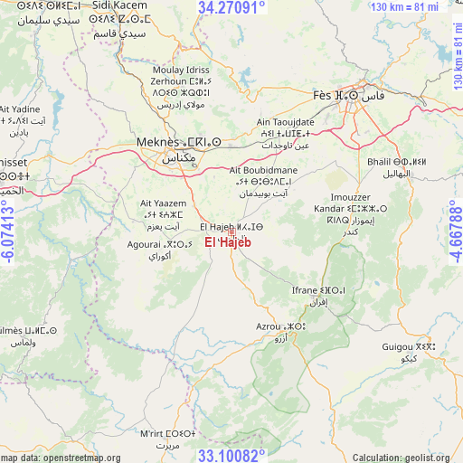
El Hajeb GPS coordinates[2]
33° 41' 16.296" North, 5° 22' 15.6" West
| Map corner | latitude | longitude |
|---|---|---|
| Upper-left | 34.27091°, | -6.07413° |
| Center: | 33.68786°, | -5.371° |
| Lower-right: | 33.10082°, | -4.66788° |
| Map W x H: | 130.1×130.1 km | = 80.8×80.8mi |
| max Lat: | 35.84906° ⇑40.3% North |
| El Hajeb: | 33.68786° |
| min Lat: | ⇓59.7% South 22.6558° |
| min Long | El Hajeb | max Long |
| -15.60719° | -5.371° | -1.22855° |
| W 60.5%⇐ | ⇒39.5% E |
Elevation
Elevation of El Hajeb is 1023 m = 3356 ft, and this is 406.2 m = 1333 ft above average elevation for this country.
| Max E: |
2637 m = 8652 ft | 23.3% |
| El Hajeb | 1023 m 3356 ft | |
| Avg. | 616.8 m = 2024 ft | |
Min E: |
1 m = 3 ft | 76.7% |
See also: Morocco elevation on elevation.city.
Geographical zone
El Hajeb is located in North temperate zone (between Tropic of Cancer and the Arctic Circle). Distance of this Northern Tropic circle is 1139.8 km =708.2 mi to South.| Distance of | km | miles | from El Hajeb |
|---|---|---|---|
| North Pole | 6261.3 | 3890.6 | to North |
| Arctic Circle | 3655.4 | 2271.4 | to North |
| Tropic Cancer | 1139.8 | 708.2 | to South |
| Equator | 3745.7 | 2327.5 | to South |


Nearby cities:
15 places around El Hajeb: (largest is in red/bold)
• Azrou
31.4 km =19.5 mi,  153°
153°
• Aïn Leuh
44.4 km =27.6 mi,  176°
176°
• Bhalil
49.6 km =30.8 mi,  68°
68°
• Fès
51.4 km =31.9 mi,  41°
41°
• Fès al Bali
57.3 km =35.6 mi, 42°
• Ifrane
30.1 km =18.7 mi,  126°
126°
• Khemisset
66 km =41 mi,  283°
283°
• Meknès
28.1 km =17.5 mi,  324°
324°
• Moulay Yacoub
47.8 km =29.7 mi,  21°
21°
• Oulad Tayeb
45.1 km =28 mi,  50°
50°
• Oulmes
65.3 km =40.6 mi,  243°
243°
• Sefrou
52.7 km =32.7 mi, 72°
• Sidi Harazem
58.7 km =36.5 mi, 50°
• Sidi Qacem
67 km =41.6 mi,  332°
332°
• Tazouta
68.2 km =42.4 mi,  91°
91°
Sources, notices
• [Note1] Compared only with cities in Morocco existing in our database
• [Src1] Map data: © OpenStreetMap contributors (CC-BY-SA)
• [Src2] Other city data from geonames.org with taken over terms of usage.
• [Src3] Geographical zone / Annual Mean Temperature by Robert A. Rohde @ Wikipedia
