Zawyat an Nwaçer geodata
Zawyat an Nwaçer (Casablanca-Settat) is a populated place; located in Morocco in Africa/Casablanca (GMT+1) time zone. With population of 12,696 people, there are 86 cities with bigger population in this country. Compared to other cities in Morocco, 54.7% of cities are located further ↓South; 73.3% of cities are located further →East and 72.5% of cities have higher elevation than Zawyat an Nwaçer. Note1


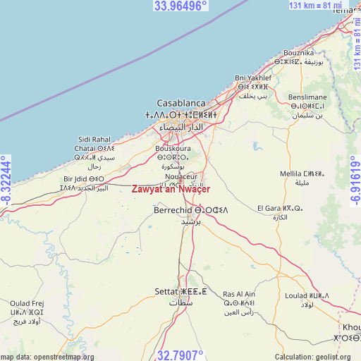
Zawyat an Nwaçer GPS coordinates[2]
33° 22' 47.316" North, 7° 37' 9.552" West
| Map corner | latitude | longitude |
|---|---|---|
| Upper-left | 33.96496°, | -8.32244° |
| Center: | 33.37981°, | -7.61932° |
| Lower-right: | 32.7907°, | -6.91619° |
| Map W x H: | 130.6×130.6 km | = 81.2×81.2mi |
| max Lat: | 35.84906° ⇑45.3% North |
| Zawyat an Nwaçer: | 33.37981° |
| min Lat: | ⇓54.7% South 22.6558° |
| min Long | Zawyat an Nwaç | max Long |
| -15.60719° | -7.61932° | -1.22855° |
| W 26.7%⇐ | ⇒73.3% E |
Elevation
Elevation of Zawyat an Nwaçer is 195 m = 640 ft, and this is 421.8 m = 1384 ft below average elevation for this country.
| Max E: |
2637 m = 8652 ft | 72.5% |
| Avg. | 616.8 m = 2024 ft | |
| Zawyat an Nwaçer | 195 m = 640 ft | |
Min E: |
1 m = 3 ft | 27.5% |
See also: Morocco elevation on elevation.city.
Geographical zone
Zawyat an Nwaçer is located in North temperate zone (between Tropic of Cancer and the Arctic Circle). Distance of this Northern Tropic circle is 1105.6 km =687 mi to South.| Distance of | km | miles | from Zawyat an Nwaçer |
|---|---|---|---|
| North Pole | 6295.6 | 3911.9 | to North |
| Arctic Circle | 3689.7 | 2292.7 | to North |
| Tropic Cancer | 1105.6 | 687 | to South |
| Equator | 3711.5 | 2306.2 | to South |


Nearby cities:
15 places around Zawyat an Nwaçer: (largest is in red/bold)
• Azemmour
67.9 km =42.2 mi,  261°
261°
• Berrechid
13 km =8.1 mi,  166°
166°
• Boulaouane
70.7 km =43.9 mi,  215°
215°
• Bouskoura
8.4 km =5.2 mi,  338°
338°
• Bouznika
62.3 km =38.7 mi,  43°
43°
• Casablanca
23.2 km =14.4 mi,  1°
1°
• Dar Bouazza
23.7 km =14.7 mi,  309°
309°
• Guisser
69.1 km =42.9 mi, 170°
• Mediouna
12.2 km =7.6 mi,  49°
49°
• Mellila
44.5 km =27.7 mi,  89°
89°
• Mohammedia
40.5 km =25.2 mi,  32°
32°
• Oulad Frej
73.4 km =45.6 mi,  230°
230°
• Riah
34.1 km =21.2 mi,  138°
138°
• Settat
42.1 km =26.2 mi,  179°
179°
• Tit Mellil
23.3 km =14.5 mi, 31°
Sources, notices
• [Note1] Compared only with cities in Morocco existing in our database
• [Src1] Map data: © OpenStreetMap contributors (CC-BY-SA)
• [Src2] Other city data from geonames.org with taken over terms of usage.
• [Src3] Geographical zone / Annual Mean Temperature by Robert A. Rohde @ Wikipedia
