Settat geodata
Settat (Casablanca-Settat) is a seat of a second-order administrative division; located in Morocco in Africa/Casablanca (GMT+1) time zone. With population of 119,082 people, there are 21 cities with bigger population in this country. Compared to other cities in Morocco, 50% of cities are located further ↓South; 72.9% of cities are located further →East and 57.4% of cities have higher elevation than Settat. Note1
Administrative division(s):
- Level 1: Casablanca-Settat
- Level 2: Settat Province
- Level 3: Settat City


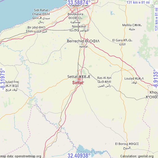
Settat GPS coordinates[2]
33° 0' 3.708" North, 7° 36' 59.832" West
| Map corner | latitude | longitude |
|---|---|---|
| Upper-left | 33.58874°, | -8.31975° |
| Center: | 33.00103°, | -7.61662° |
| Lower-right: | 32.40938°, | -6.9135° |
| Map W x H: | 131.1×131.1 km | = 81.5×81.5mi |
| max Lat: | 35.84906° ⇑50% North |
| Settat: | 33.00103° |
| min Lat: | ⇓50% South 22.6558° |
| min Long | Settat | max Long |
| -15.60719° | -7.61662° | -1.22855° |
| W 27.1%⇐ | ⇒72.9% E |
Elevation
Elevation of Settat is 365 m = 1198 ft, and this is 251.8 m = 826 ft below average elevation for this country.
| Max E: |
2637 m = 8652 ft | 57.4% |
| Avg. | 616.8 m = 2024 ft | |
| Settat | 365 m = 1198 ft | |
Min E: |
1 m = 3 ft | 42.6% |
See also: Settat elevation on elevation.city.
Geographical zone
Settat is located in North temperate zone (between Tropic of Cancer and the Arctic Circle). Distance of this Northern Tropic circle is 1063.5 km =660.8 mi to South.| Distance of | km | miles | from Settat |
|---|---|---|---|
| North Pole | 6337.7 | 3938.1 | to North |
| Arctic Circle | 3731.8 | 2318.8 | to North |
| Tropic Cancer | 1063.5 | 660.8 | to South |
| Equator | 3669.4 | 2280.1 | to South |


Nearby cities:
15 places around Settat: (largest is in red/bold)
• Azemmour
74.8 km =46.5 mi,  295°
295°
• Berrechid
29.5 km =18.3 mi,  5°
5°
• Boulaouane
43.9 km =27.3 mi,  249°
249°
• Bouskoura
50 km =31.1 mi,  356°
356°
• Casablanca
65.3 km =40.6 mi,  0°
0°
• Dar Bouazza
60.1 km =37.3 mi,  341°
341°
• Guisser
28.3 km =17.6 mi,  157°
157°
• Khouribga
67.6 km =42 mi,  101°
101°
• Mediouna
50.9 km =31.6 mi, 10°
• Mellila
61.2 km =38 mi,  46°
46°
• Oulad Frej
57.2 km =35.5 mi,  265°
265°
• Riah
28 km =17.4 mi, 53°
• Sidi Abdallah
55.6 km =34.5 mi,  201°
201°
• Tit Mellil
63.1 km =39.2 mi, 11°
• Zawyat an Nwaçer
42.1 km =26.2 mi, 359°
Sources, notices
• [Note1] Compared only with cities in Morocco existing in our database
• [Src1] Map data: © OpenStreetMap contributors (CC-BY-SA)
• [Src2] Other city data from geonames.org with taken over terms of usage.
• [Src3] Geographical zone / Annual Mean Temperature by Robert A. Rohde @ Wikipedia
