Azemmour geodata
Azemmour (Casablanca-Settat) is a seat of a third-order administrative division; located in Morocco in Africa/Casablanca (GMT+1) time zone. With population of 37,140 people, there are 60 cities with bigger population in this country. Compared to other cities in Morocco, 52.7% of cities are located further ↓South; 81.4% of cities are located further →East and 89.5% of cities have higher elevation than Azemmour. Note1


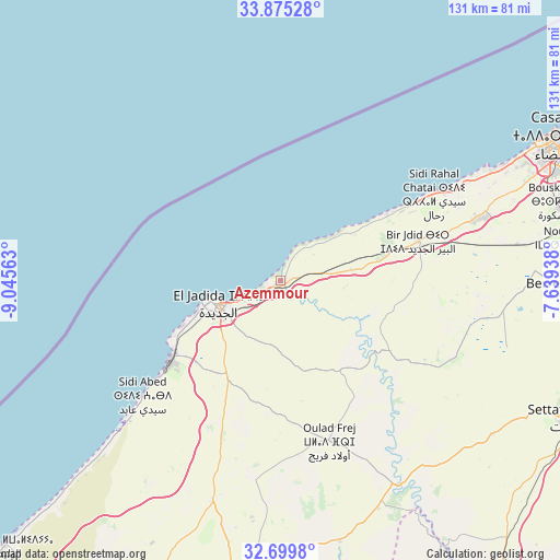
Azemmour GPS coordinates[2]
33° 17' 22.272" North, 8° 20' 33" West
| Map corner | latitude | longitude |
|---|---|---|
| Upper-left | 33.87528°, | -9.04563° |
| Center: | 33.28952°, | -8.3425° |
| Lower-right: | 32.6998°, | -7.63938° |
| Map W x H: | 130.7×130.7 km | = 81.2×81.2mi |
| max Lat: | 35.84906° ⇑47.3% North |
| Azemmour: | 33.28952° |
| min Lat: | ⇓52.7% South 22.6558° |
| min Long | Azemmour | max Long |
| -15.60719° | -8.3425° | -1.22855° |
| W 18.6%⇐ | ⇒81.4% E |
Elevation
Elevation of Azemmour is 28 m = 92 ft, and this is 588.8 m = 1932 ft below average elevation for this country.
| Max E: |
2637 m = 8652 ft | 89.5% |
| Avg. | 616.8 m = 2024 ft | |
| Azemmour | 28 m = 92 ft | |
Min E: |
1 m = 3 ft | 10.5% |
See also: Morocco elevation on elevation.city.
Geographical zone
Azemmour is located in North temperate zone (between Tropic of Cancer and the Arctic Circle). Distance of this Northern Tropic circle is 1095.5 km =680.7 mi to South.| Distance of | km | miles | from Azemmour |
|---|---|---|---|
| North Pole | 6305.6 | 3918.1 | to North |
| Arctic Circle | 3699.7 | 2298.9 | to North |
| Tropic Cancer | 1095.5 | 680.7 | to South |
| Equator | 3701.4 | 2299.9 | to South |


Nearby cities:
15 places around Azemmour: (largest is in red/bold)
• Berrechid
70.2 km =43.6 mi,  92°
92°
• Boulaouane
54.7 km =34 mi,  150°
150°
• Bouskoura
66.5 km =41.3 mi,  74°
74°
• Casablanca
75.5 km =46.9 mi,  63°
63°
• Dar Bouazza
54.9 km =34.1 mi, 62°
• El Jadid
15.9 km =9.9 mi,  256°
256°
• Mediouna
78.5 km =48.8 mi,  76°
76°
• Moulay Abdallah
25.1 km =15.6 mi,  245°
245°
• Oualidia
89.1 km =55.4 mi,  226°
226°
• Oulad Frej
38.2 km =23.7 mi,  163°
163°
• Settat
74.8 km =46.5 mi,  115°
115°
• Sidi Bennour
71.3 km =44.3 mi,  186°
186°
• Sidi Smai’il
54 km =33.6 mi,  196°
196°
• Tit Mellil
84.9 km =52.8 mi, 69°
• Zawyat an Nwaçer
67.9 km =42.2 mi, 81°
Sources, notices
• [Note1] Compared only with cities in Morocco existing in our database
• [Src1] Map data: © OpenStreetMap contributors (CC-BY-SA)
• [Src2] Other city data from geonames.org with taken over terms of usage.
• [Src3] Geographical zone / Annual Mean Temperature by Robert A. Rohde @ Wikipedia
