Bouarfa geodata
Bouarfa (Oriental) is a seat of a third-order administrative division; located in Morocco in Africa/Casablanca (GMT+1) time zone. With population of 28,846 people, there are 70 cities with bigger population in this country. Compared to other cities in Morocco, 58.9% of cities are located further ↑North; 98.8% of cities are located further ←West and 83.7% of cities have lower elevation than Bouarfa. Note1


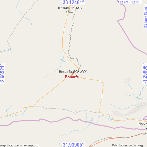
Bouarfa GPS coordinates[2]
32° 32' 1.644" North, 1° 57' 43.524" West
| Map corner | latitude | longitude |
|---|---|---|
| Upper-left | 33.12461°, | -2.66521° |
| Center: | 32.53379°, | -1.96209° |
| Lower-right: | 31.93905°, | -1.25896° |
| Map W x H: | 131.8×131.8 km | = 81.9×81.9mi |
| max Lat: | 35.84906° ⇑58.9% North |
| Bouarfa: | 32.53379° |
| min Lat: | ⇓41.1% South 22.6558° |
| min Long | Bouarfa | max Long |
| -15.60719° | -1.96209° | -1.22855° |
| W 98.8%⇐ | ⇒1.2% E |
Elevation
Elevation of Bouarfa is 1169 m = 3835 ft, and this is 552.2 m = 1812 ft above average elevation for this country.
| Max E: |
2637 m = 8652 ft | 16.3% |
| Bouarfa | 1169 m 3835 ft | |
| Avg. | 616.8 m = 2024 ft | |
Min E: |
1 m = 3 ft | 83.7% |
See also: Morocco elevation on elevation.city.
Geographical zone
Bouarfa is located in North temperate zone (between Tropic of Cancer and the Arctic Circle). Distance of this Northern Tropic circle is 1011.5 km =628.5 mi to South.| Distance of | km | miles | from Bouarfa |
|---|---|---|---|
| North Pole | 6389.6 | 3970.3 | to North |
| Arctic Circle | 3783.8 | 2351.1 | to North |
| Tropic Cancer | 1011.5 | 628.5 | to South |
| Equator | 3617.4 | 2247.7 | to South |


Nearby cities:
15 places around Bouarfa: (largest is in red/bold)
• Almis Marmoucha
224.7 km =139.6 mi,  292°
292°
• Amersid
236.1 km =146.7 mi,  275°
275°
• Aoufous
228.6 km =142 mi,  245°
245°
• Aïn Beni Mathar
164.2 km =102 mi,  357°
357°
• Debdou
189.8 km =117.9 mi,  328°
328°
• El Aïoun
233.4 km =145 mi,  347°
347°
• Figuig (Centre)
83.6 km =51.9 mi,  124°
124°
• Guenfouda
216.9 km =134.8 mi, 357°
• Guercif
228.2 km =141.8 mi, 325°
• Jerada
198.3 km =123.2 mi, 354°
• Missour
198 km =123 mi, 286°
• Oujda-Angad
238.8 km =148.4 mi,  1°
1°
• Talzemt
238.5 km =148.2 mi,  299°
299°
• Taourirt
225.7 km =140.2 mi,  337°
337°
• Tiouli
204.1 km =126.8 mi, 3°
Sources, notices
• [Note1] Compared only with cities in Morocco existing in our database
• [Src1] Map data: © OpenStreetMap contributors (CC-BY-SA)
• [Src2] Other city data from geonames.org with taken over terms of usage.
• [Src3] Geographical zone / Annual Mean Temperature by Robert A. Rohde @ Wikipedia
