Missour geodata
Missour (Fès-Meknès) is a seat of a third-order administrative division; located in Morocco in Africa/Casablanca (GMT+1) time zone. In our database, there are 108 cities with bigger population. Compared to other cities in Morocco, 50.4% of cities are located further ↓South; 87.2% of cities are located further ←West and 68.2% of cities have lower elevation than Missour. Note1


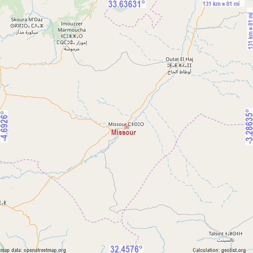
Missour GPS coordinates[2]
33° 2' 56.148" North, 3° 59' 22.092" West
| Map corner | latitude | longitude |
|---|---|---|
| Upper-left | 33.63631°, | -4.6926° |
| Center: | 33.04893°, | -3.98947° |
| Lower-right: | 32.4576°, | -3.28635° |
| Map W x H: | 131.1×131.1 km | = 81.5×81.5mi |
| max Lat: | 35.84906° ⇑49.6% North |
| Missour: | 33.04893° |
| min Lat: | ⇓50.4% South 22.6558° |
| min Long | Missour | max Long |
| -15.60719° | -3.98947° | -1.22855° |
| W 87.2%⇐ | ⇒12.8% E |
Elevation
Elevation of Missour is 883 m = 2897 ft, and this is 266.2 m = 873 ft above average elevation for this country.
| Max E: |
2637 m = 8652 ft | 31.8% |
| Missour | 883 m 2897 ft | |
| Avg. | 616.8 m = 2024 ft | |
Min E: |
1 m = 3 ft | 68.2% |
See also: Morocco elevation on elevation.city.
Geographical zone
Missour is located in North temperate zone (between Tropic of Cancer and the Arctic Circle). Distance of this Northern Tropic circle is 1068.8 km =664.1 mi to South.| Distance of | km | miles | from Missour |
|---|---|---|---|
| North Pole | 6332.4 | 3934.8 | to North |
| Arctic Circle | 3726.5 | 2315.5 | to North |
| Tropic Cancer | 1068.8 | 664.1 | to South |
| Equator | 3674.7 | 2283.4 | to South |


Nearby cities:
15 places around Missour: (largest is in red/bold)
• Almis Marmoucha
35 km =21.7 mi,  329°
329°
• Amersid
55.9 km =34.7 mi,  233°
233°
• Azrou
122.3 km =76 mi,  290°
290°
• Bhalil
121.2 km =75.3 mi,  317°
317°
• Boulemane
77.2 km =48 mi,  296°
296°
• Boumia
110 km =68.4 mi,  250°
250°
• Ifrane
116.9 km =72.6 mi, 297°
• Itzer
100.9 km =62.7 mi,  259°
259°
• Midelt
81.3 km =50.5 mi,  240°
240°
• Sefrou
116.8 km =72.6 mi, 318°
• Tahla
118.3 km =73.5 mi,  340°
340°
• Talzemt
63 km =39.1 mi, 342°
• Tazarine
94.5 km =58.7 mi,  348°
348°
• Tazouta
91.4 km =56.8 mi, 319°
• Tmourghout
95.4 km =59.3 mi,  357°
357°
Sources, notices
• [Note1] Compared only with cities in Morocco existing in our database
• [Src1] Map data: © OpenStreetMap contributors (CC-BY-SA)
• [Src2] Other city data from geonames.org with taken over terms of usage.
• [Src3] Geographical zone / Annual Mean Temperature by Robert A. Rohde @ Wikipedia
