Tvardița geodata
Tvardița (Taraclia) is a populated place; located in Moldova in Europe/Chisinau (GMT+3) time zone. With population of 5,800 people, there are 53 cities with bigger population in this country. Compared to other cities in Moldova, 93.2% of cities are located further ↑North; 68.5% of cities are located further ←West and 60.3% of cities have lower elevation than Tvardița. Note1


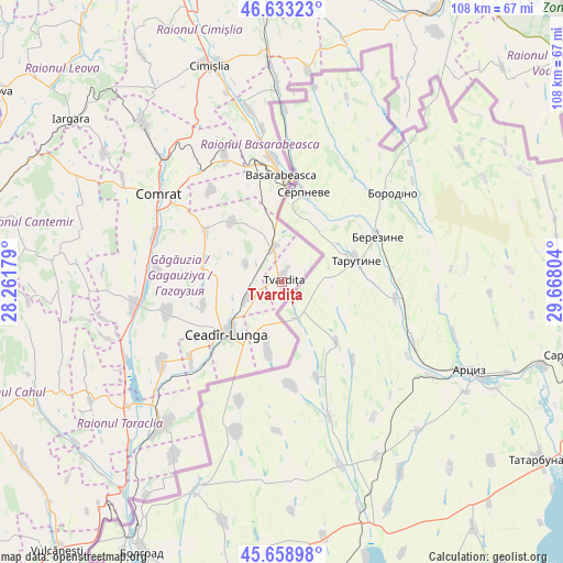
Tvardița GPS coordinates[2]
46° 8' 53.736" North, 28° 57' 53.676" East
| Map corner | latitude | longitude |
|---|---|---|
| Upper-left | 46.63323°, | 28.26179° |
| Center: | 46.14826°, | 28.96491° |
| Lower-right: | 45.65898°, | 29.66804° |
| Map W x H: | 108.3×108.3 km | = 67.3×67.3mi |
| max Lat: | 48.43285° ⇑93.2% North |
| Tvardița: | 46.14826° |
| min Lat: | ⇓6.8% South 45.48167° |
| min Long | Tvardița | max Long |
| 27.07787° | 28.96491° | 29.9617° |
| W 68.5%⇐ | ⇒31.5% E |
Elevation
Elevation of Tvardița is 104 m = 341 ft, and this is 11.2 m = 37 ft above average elevation for this country.
| Max E: |
241 m = 791 ft | 39.7% |
| Tvardița | 104 m 341 ft | |
| Avg. | 92.8 m = 304 ft | |
Min E: |
11 m = 36 ft | 60.3% |
See also: Moldova elevation on elevation.city.
Geographical zone
Tvardița is located in North temperate zone (between Tropic of Cancer and the Arctic Circle). Distance of this North polar circle is 2270 km =1410.5 mi to North.| Distance of | km | miles | from Tvardița |
|---|---|---|---|
| North Pole | 4875.9 | 3029.7 | to North |
| Arctic Circle | 2270 | 1410.5 | to North |
| Tropic Cancer | 2525.3 | 1569.1 | to South |
| Equator | 5131.2 | 3188.4 | to South |


Nearby cities:
15 places around Tvardița: (largest is in red/bold)
• Basarabeasca
20.4 km =12.7 mi,  359°
359°
• Bugeac
33.5 km =20.8 mi,  316°
316°
• Cahul
65 km =40.4 mi,  245°
245°
• Cantemir
60.4 km =37.5 mi,  283°
283°
• Ceadîr-Lunga
14.1 km =8.8 mi,  227°
227°
• Cimişlia
44.8 km =27.8 mi,  339°
339°
• Comrat
28.8 km =17.9 mi,  304°
304°
• Căuşeni
64.2 km =39.9 mi,  32°
32°
• Hînceşti
81.1 km =50.4 mi, 339°
• Iargara
51.6 km =32.1 mi,  306°
306°
• Leova
66.1 km =41.1 mi, 304°
• Taraclia
35.6 km =22.1 mi,  220°
220°
• Vişniovca
44.7 km =27.8 mi, 297°
• Vulcăneşti
67.2 km =41.8 mi, 219°
• Ştefan Vodă
67.1 km =41.7 mi,  52°
52°
Sources, notices
• [Note1] Compared only with cities in Moldova existing in our database
• [Src1] Map data: © OpenStreetMap contributors (CC-BY-SA)
• [Src2] Other city data from geonames.org with taken over terms of usage.
• [Src3] Geographical zone / Annual Mean Temperature by Robert A. Rohde @ Wikipedia
